Case Studies

Utilizing Tipping and Cueing for Enhanced Visibility

The maritime domain is one of the most complex and challenging operational environments. The vastness of the ocean makes it difficult to monitor and to know where and when to look for deceptive shipping practices (DSPs) and suspicious behavior. Globally, persistent monitoring and collection are impossible to scale with existing sensor deployment capabilities. No one approach or technology can serve as a single source of truth and capture the full picture of what is occurring at sea.

The Current Status Quo is Not Enough

The “Covered Area” Fallacy

National assets have a limited number of sensors. They are struggling to cover all seas and oceans and to provide timely data for analysts and decision makers. National-level assets are often restricted to specific revisit times and a competitive target list, which equates to even the “covered areas” not being observed 24/7. By default, analysts are looking backward at the area they are investigating with no real-time context.

This is where commercial intelligence, surveillance, and reconnaissance (ISR) comes in. Commercial satellites complement existing government assets and streamline broad sharing agreements with allies and partner nations that can’t always be achieved with national-level assets alone.

Predictive Analytics and Tipping & Cueing: a Transformative Combination

Tipping and cueing refers to the leveraging of AIS transmissions and remote sensing data to provide specific information about vessels, or other objects of interest. Possible issues are identified in low resolution (“tipping”) and then satellites can zoom in on that area (“cueing”) to clarify. Due to some of the limitations mentioned above, such as the covered area fallacy and satellite latency, tipping and cueing does not provide the full picture of battle space activities. 

Adding predictive analytics to remote sensing tipping and cueing can transform operations and decision-making processes. Predictive analytics enrich the process by applying advanced algorithms to analyze behavioral trends and forecast future events.

For example, predictive analytics can forecast weather patterns, ocean currents, and other environmental factors, allowing maritime operators to make informed decisions and prepare for potential obstacles and threats. The technology can also analyze vessel traffic patterns and predict congestion, allowing operators to avoid bottlenecks and reduce the risk of collisions.

In addition, predictive analytics can be used to analyze historical vessel trends and monitor the real-time movements of entities such as adversary ships, or vessels engaging in illegal activities. Identifying future, or otherwise unknown events, provides valuable data for maritime law enforcement and contributes to maintaining international maritime security.

Information Sharing is the Foundation of Future Solutions

The future of maritime operations lies in the integration of remote sensing tipping and cueing, and predictive analytics. A multi-source approach combining both predictive intelligence and remote sensing technology can transform a sea of raw data into actionable recommendations. It will enable true tipping and queuing so that stakeholders can detect, identify, and monitor vessels in real-time, within any area of interest, globally.

As technology advances, the maritime domain’s possibilities for remote sensing and predictive analytics are endless. The naval community is poised to reap the benefits of this innovative technology via enhanced situational awareness, optimized missions, increased security cooperation and information sharing, and safer, more secure seas.  

The next step requires harnessing Maritime AI™. Advanced behavioral analysis in decision-making can assist in understanding where to deploy assets, capture satellite imagery, and dramatically increase operational efficiency and return on investment (ROI).

Probability vs. Opportunity: a Multi-Source Case Study

Knowing the odds can enable you to place your bets strategically, much like the blackjack players depicted in movies who triumph over the casino.

Here is how a leading intelligence unit leveraged Maritime AI™, SAR and optical imagery in one platform to gain a strategic advantage and accurately tip and cue.

To efficiently complete their operational picture, the unit first planned and defined the goal of tasking: obtain evidence of foreign military presence in the Philippines EEZ.

With their defined mission in mind, they leveraged Windward’s Maritime AI™ and behavioral analysis to identify the location with the highest probability of tasking success. This was done with a simple query of military vessels engaged in slow speed operations (indication for maritime patrol) in the Philippines EEZ.

For Blog web page 5

With the search results and the identified polygon for the tasking, the unit was still missing the trigger for the tasking (timing, behavioral).
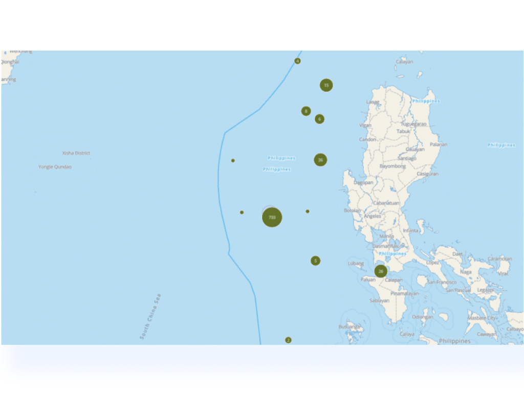
Within the defined polygon, the unit investigated the operations of non-commercial vessels to discover the following sequence and timeline:

  • Departure from China coast guard dock
  • 2 days later – the vessels arrive at the area of patrol in the Philippines EEZ
  • 1 day later – the replaced vessel departs from the area of patrol

By creating a custom polygon around the identified docks of interest, the unit customized alerts on triggers for tasking assets of importance, so as and not to miss a valuable opportunity.

For Blog web page 6 1

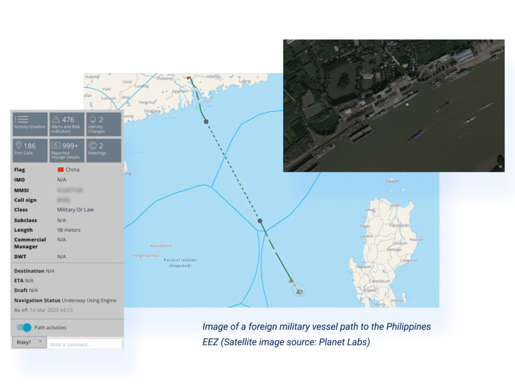
With the identified location, trigger, and timing in hand, the unit tasked SAR imagery and got the below images proving the sequence they discovered in the data. However, without vessel details and context, it’s difficult to make sense of the image or use it in their investigation.

For Blog web page 7

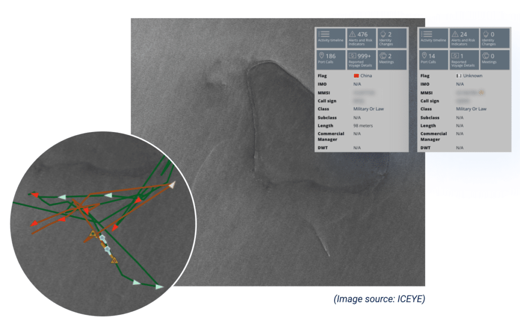
To leverage the SAR imagery further, the unit seamlessly integrated it into the Windward platform. Following this overlay with Windward AI’s fused identity layers, the actionable insights were highlighted to help drive the investigation deeper:

For Blog web page 8

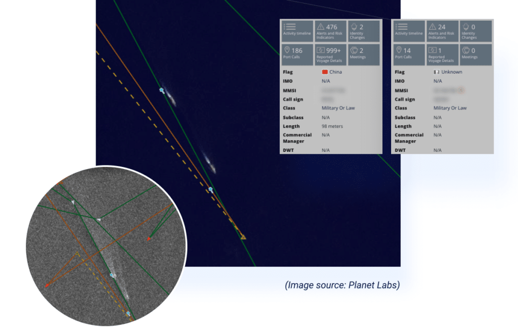
Windward’s agnostic multi-source AI platform also provides an additional optical imagery sensor source (Planet Labs), which corroborated the vessels’ location, and added context for the investigated operation.

Looking to Increase Visibility & Optimize Your Decision Making?