


July 7, 2026
Hormuz's NCAGS Corridor Under Attack: Two Laden Tankers Struck Overnight


Ireland’s Massive Cocaine Bust Reveals Hidden Details with Maritime AI™
What’s inside?
A massive maritime drug bust in Ireland unsurprisingly made waves in the mainstream media.
According to CNN:
“Cocaine weighing 2,253 kg, worth an estimated 157 million euros ($165 million), was seized from the vessel ‘MV Matthew’ traveling from South America, Director General of Revenue and Customs Gerry Harrahill said at a news conference in Dublin Wednesday.
‘It is the largest drug seizure in the history of the State,’ Justin Kelly, Assistant Commissioner of An Garda Síochána, Ireland’s police force, said at the same conference.”
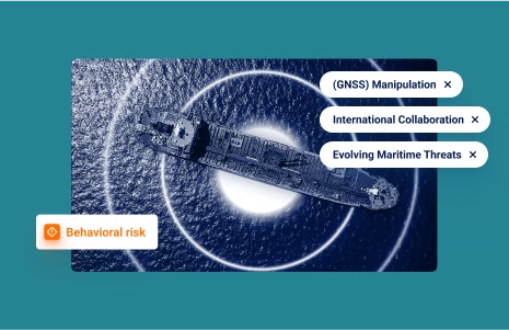
Despite the great media coverage, outlets didn’t report one critical risk indicator, likely because it can only be detected by a Maritime AI™ platform: the vessel in question engaged in location (GNSS) manipulation in an attempt to evade detection.
Location (GNSS) manipulation is the use of a machine-generated location/path to disguise the true location of a vessel. Multiple methods have been identified to carry out this deception, including false transmission onboard a vessel and third-party onshore accomplices.
Windward’s Customers Were Already on Alert
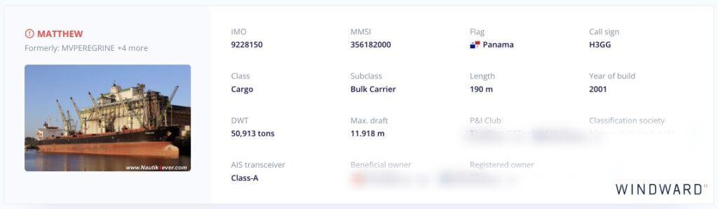
Prior to its fateful last journey, the vessel was named MV Honmon (Honmon) and the vessel’s commercial manager was a Chinese-based company. The Honmon’s name was changed to MV Matthew (Matthew) for this latest smuggling attempt and its commercial manager was altered to a Hong Kong-based company on May 8, 2023.
The vessel is a 190-meter bulk carrier that was sailing under Panama’s flag, which is a flag of convenience and was coming from South America before being apprehended.
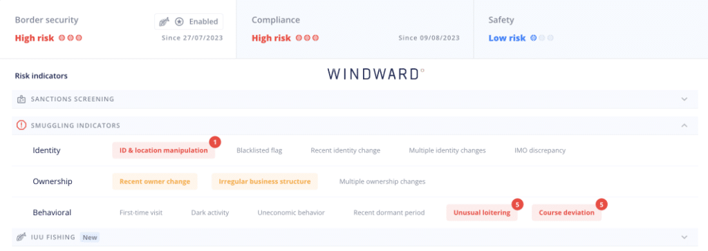
The ship has been marked as “high risk” by Windward’s Maritime AI™ platform since July 2023.
The Irish Revenue Customs Service, the navy, and An Garda Síochána joined forces to capture the vessel, according to the Garda press release.
Suspicious Behavior and Location (GNSS) Manipulation
The Honmon departed the port of Pecem, Brazil on June 6 and updated its draft from 10.6 to 6, suggesting that the vessel offloaded cargo while in port. It then updated its destination to the port of Fortaleza, Brazil.
The vessel sailed towards the Caribbean area on July 17. It entered the EEZ of the Netherlands Antilles for the first time on July 24 and sailed between the Antilles, Venezuela, and Colombia.
While sailing in the area, the vessel conducted several slow speed activities (sailing under three knots), although it did not engage in ship-to-ship or other types of meetings. The vessel made a port call in Curacao on August 9. Check out Honmon’s inefficient/uneconomical sailing path between May 30-August 19, 2023. The red triangles in the zoomed-in area show where the vessel slowed down. This, plus the zigzagging pattern, are clear indications of loitering.
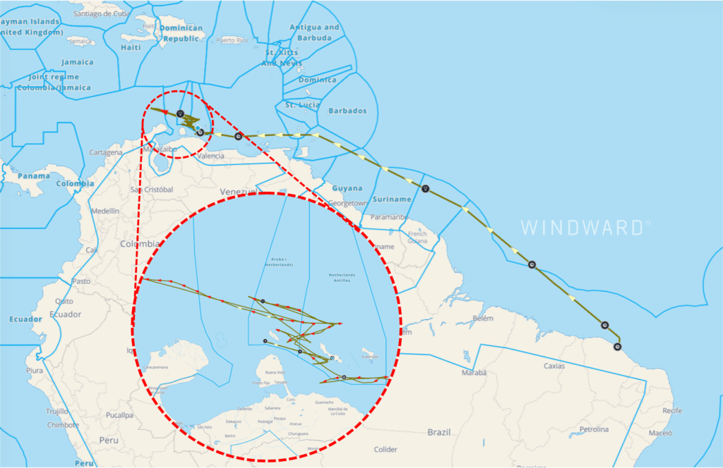
After departing from the Curacao port on August 19, the vessel updated its name to MV Matthew (Matthew) and its destination to Santos, Brazil.
While sailing in Guyana’s exclusive economic zone (EEZ) on August 22, the Matthew appeared to again loiter, but it was actually engaged in location (GNSS) manipulation. The vessel ended its location (GNSS) manipulation and resumed legitimate transmission on September 7, updating its destination to the port of Gdansk, Poland. The vessel then began crossing the North Atlantic Ocean.
The below image shows Matthew’s sailing path from August 19-September 7, including location (GNSS) manipulation. The circular path shown in the zoomed-in area would be impossible for a vessel of Matthew’s size, raising suspicions (plus, why would the vessel travel in a circle?).
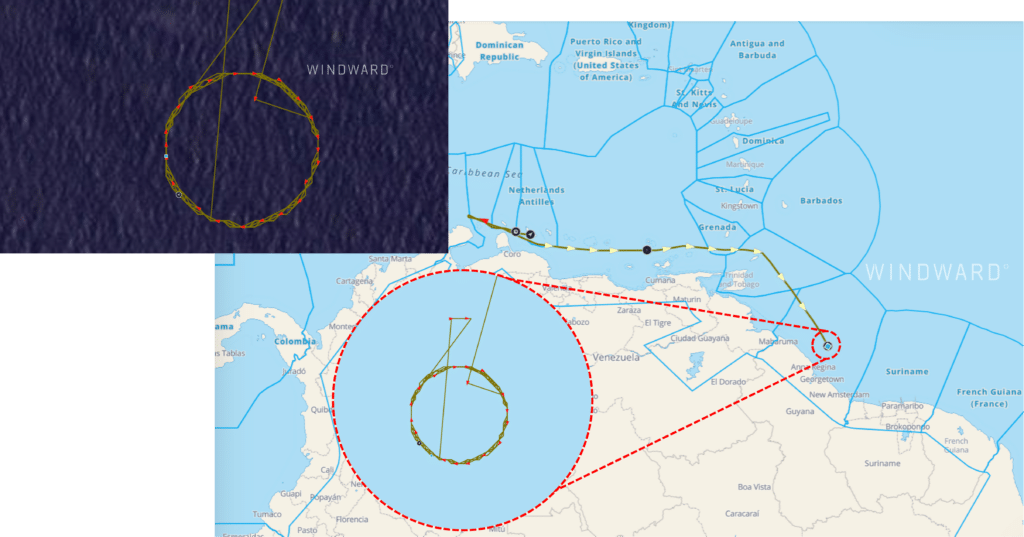
A satellite image from Planet Labs shows that the Matthew was NOT where it claimed to be.
While crossing the North Atlantic Ocean on September 10, the vessel updated its registered owner, changing to “Matthew Maritime Inc.,” a Marshall Island-based company, where it was the only registered vessel. Changing ownership to a company with the same name as the vessel – and which only has a single vessel in its fleet – is certainly an eyebrow-raising move.
The vessel updated its destination to Belfast on September 23, after entering the UK’s EEZ. On September 24, it again updated its destination, this time to the port of Cork, making a port call there on September 26.
The next day, it was reported that the vessel was detained by local Irish authorities while carrying over two tons of cocaine! As noted in this blog post, the signs were there for all to see…
Why You Should Care
This is more than just one sensational incident…
Location (GNSS) manipulation methodologies are growing at an exponential speed compared to previous deceptive shipping practices.
Windward’s Maritime AI™ platform found a 12% increase in location (GNSS) manipulation during the first half of 2023 compared to the same period the year before, as well as an 82% increase compared to H1 2021.
The manipulation of vessels’ AIS-transmitted locations is a fast-growing trend that has attracted the attention of regulators, as well as navies and defense agencies. The maritime ecosystem is advised to follow the lead of the regulators to avoid missing a vessel such as the Matthew.
Best practices are nowhere near as simple as merely detecting dark activity, or screening for sanctions lists, although both are still relevant and necessary. The cat-and-mouse game continues to evolve at warp speed, with complicated ID manipulation schemes and other advanced deceptive shipping practices.
The law enforcement operation to detain Matthew was performed by three different intelligence and law enforcement bodies across Europe. The required information sharing and collaboration to generate a common operating picture can only be produced by a Maritime AI™ platform.
Also, a problem for national intelligence, defense, and law enforcement organizations – as well as many others throughout the maritime ecosystem who are required to detect, identify, and monitor vessels – is that no approach or technology can serve as a single source of truth and provide a holistic view of risk. Being able to verify the incident of location (GNSS) manipulation with a satellite image from Planet Labs shows the value of multi-source technology.
I Don’t Want to Miss Smuggling Attempts
Explore more

What Is GPS Jamming and Why Are We Seeing So Much of It?
At a Glance What Is GPS Jamming? GPS jamming is the deliberate interference with GPS signals that disrupts the ability of receivers to determine accurate location. It operates in two primary modes. The first is signal denial, where jamming equipment overwhelms the GPS signal with radio frequency interference, preventing a receiver from establishing a positioning...
Read more

Why Russian-Linked Vessels Are Loitering Above European Subsea Cables
At a Glance Behavior With No Commercial Explanation The signature is consistent across multiple vessels in different parts of European waters. A tanker arcs off its expected route. It loiters above a cable system, sometimes for hours, sometimes for days. Its AIS goes dark for long enough to obscure precise positioning but short enough to...
Read more

Why Russia’s Sanctioned Shadow Fleet Is Bypassing the English Channel
At a Glance Russian Tankers Repeatedly Bypass the English Channel Western-sanctioned tankers loading oil at Russian Baltic ports normally transit the English Channel as part of standard voyage routing. In the past 30 days, Windward tracked 84 Western-sanctioned tankers through the Channel — 44% flagged with Sierra Leone, 19% with Cameroon, and 18% with Russia....
Read more

Why Customs Enforcement Is Moving from Document Screening to Behavioral Intelligence
At a Glance The Screening Model Customs Was Built On No Longer Holds For most of the last twenty years, customs enforcement has operated on a screening model. Cargo manifests arrive ahead of port call, risk scores are calculated against the declared origin, shipper, and route, and anomalies trigger inspection. The model worked while the...
Read more

Why Behavioral Intelligence Now Defines Subsea Cable Protection
At a Glance From Monitoring to Prevention For most of the past decade, cable protection meant monitoring. Operators watched the screen, generated alerts when a vessel of concern appeared near a cable, and responded after the fact when damage occurred. The threat landscape has shifted in ways that existing tools and protocols were not designed...
Read more