


June 23, 2026
GPS Jamming Is Now a Mainstream Maritime Threat: What Changed Between 2025 and 2026


GPS Jamming Is Now a Mainstream Maritime Threat: What Changed Between 2025 and 2026

What’s inside?
At a Glance
- GPS jamming reached an estimated 978,000 events globally in Q1 2026, with 98% concentrated in the Middle East Gulf, marking the largest single-quarter concentration of maritime jamming events ever recorded.
- The trajectory began earlier, with approximately 6,700 vessels affected globally in Q4 2025 and 57% of events in the Middle East Gulf even before the Iran conflict began.
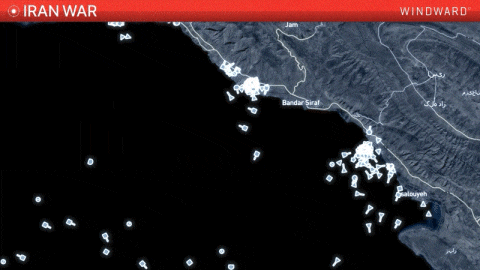
- The February 28, 2026, launch of the Iran conflict and Operation Epic Fury produced the sharpest acceleration in jamming events recorded in maritime history, with more than 1,100 vessels affected in the Middle East Gulf during the first two weeks alone.
- New jamming theaters emerged across 2025 and 2026, including Russia’s eastern port of Nakhodka, Venezuelan waters, and persistent activity across the Mediterranean, Red Sea, and Arctic regions.
- GPS jamming now operates as a routine military and operational tool, with Windward observing persistent jamming at all of Russia’s oil export ports to deter drone attacks, alongside contested waterways and active conflict theaters.
- The cumulative effect is structural, with AIS-based maritime monitoring no longer reliable as a single source in jamming-affected regions that now span four major seas.
What Changed Across 2025 and 2026
GPS jamming was not new before 2025. As a military and intelligence capability, it has existed for decades. What changed between 2025 and 2026 is the scale, geographic spread, and operational normalization of jamming events affecting global commercial shipping.
The 2025 picture established that jamming had become a persistent, multi-region phenomenon rather than an episodic disruption tied to discrete events. Across Q4 2025, approximately 6,700 vessels were affected by GPS jamming globally, down from 11,600 in Q3 2025 but still representing a sustained baseline of disruption. The geographic distribution that emerged across 2025 set the structural pattern still visible today, with 57% of Q4 2025 events concentrated in the Middle East Gulf, nearly 20% in the Black Sea, with additional activity persistent across the Mediterranean, Red Sea, the Arctic, and Russia’s eastern oil export terminals.
Q1 2026 then pushed the trajectory into mainstream territory. The Iran conflict and Operation Epic Fury, which launched on February 28, 2026, produced an unprecedented concentration of jamming events. Windward recorded approximately 978,000 events globally in the first quarter, with 98% concentrated in the Middle East Gulf and more than 1,100 vessels directly affected in the region. Within the first two weeks of the conflict, the figure climbed further, with more than 1,650 vessels affected across an expanded geographic envelope spanning Kuwait, Saudi Arabia, the UAE, Qatar, Oman, and Iran.
The contrast between the two quarters tells the story. Q4 2025 showed that GPS jamming had become a structural feature of multiple maritime regions. Q1 2026 showed that, when a major conflict erupts, the capability can be deployed at a scale that effectively saturates a strategic waterway and disrupts the AIS-based tracking that the entire maritime sector depends on.
The New Geographic Hierarchy
The geographic map of GPS jamming changed meaningfully across 2025 and 2026. Several regions stand out.
The Middle East Gulf Is Now The Dominant Theater
The Middle East Gulf, including the Strait of Hormuz and the Gulf of Oman, accounted for 98% of all jamming events globally in Q1 2026. Even before the Iran conflict began, the region was already the highest-volume jamming area in Q4 2025 at 57% of global events. The combination of pre-existing baseline activity and the conflict-driven surge has made the Middle East Gulf the single most affected maritime region in the world.
The Black Sea Remains a Persistent Secondary Theater
Driven by the Russia-Ukraine war and the broader regional security environment, the Black Sea accounted for nearly 20% of all jamming events in Q4 2025. Activity tracks closely with attacks on Russian oil export infrastructure and Ukrainian drone operations, both of which have driven a sustained jamming presence around Russian and Ukrainian ports.
Russia’s Eastern Oil Export Ports Emerged as a New Theater
Activity around Nakhodka and the nearby Kozmino oil terminal first emerged in the Q3 2025 and rose 25% quarter-on-quarter in Q4 2025, reaching approximately 750 vessels affected. Windward observes that jamming is now present at all of Russia’s oil export ports, deployed specifically to deter drone attacks on tanker loading operations.
Venezuela Joined the Map in December 2025
As the U.S. amassed its largest naval presence in the Caribbean in nearly 40 years, GPS jamming was detected off Venezuela for the first time during December 2025. Nearly 90 vessels were affected in the initial period of activity.
Persistent Activity Across the Mediterranean, Red Sea, and Arctic
These regions record sustained jamming activity tied to ongoing conflicts and the broader security environment in the Levant basin, the Bab el-Mandeb chokepoint, and Russian Arctic operations. While each of these theaters records lower volumes than the Middle East Gulf or Black Sea, the persistence across multiple quarters confirms that jamming is not concentrated in any single geographic flashpoint.
What Made GPS Jamming Mainstream
The transition from episodic disruption to structural feature was driven by three convergent factors across 2025 and 2026.
The first is active conflict, generating intense military jamming activity. The Russia-Ukraine war, the Iran conflict, and the broader gray-zone competition between major powers have all produced sustained jamming presence in the conflict theaters and surrounding waters. Military operations routinely use signal interference to protect sensitive activity from adversary tracking, deny adversary navigation, and prevent the targeting of military assets. With multiple active conflicts running simultaneously across 2025 and 2026, the cumulative volume of jamming events has reached a level no single conflict alone would have produced.
The second is infrastructure protection by state actors. Russia’s deployment of jamming at all of its oil export ports to deter Ukrainian drone strikes is the clearest documented example, but the pattern extends. State actors are increasingly using jamming as a defensive perimeter around critical infrastructure, applying the capability to maritime areas where commercial shipping must operate. The result is that jamming is no longer confined to active combat zones but extends to economic infrastructure that adversaries are seeking to disrupt.
The third is the normalization of jamming as a routine operational tool. What was once a high-end military capability deployed selectively in active conflict is now being used more routinely, by both state and non-state actors, in gray-zone competition that falls below the threshold of open conflict. GPS jamming was detected off Venezuela for the first time in December 2025, coinciding with the largest U.S. naval presence in the Caribbean in nearly 40 years. The appearance of jamming in a region where it had not previously been observed illustrates how the geographic footprint of the capability is expanding.
The cumulative effect of these three factors is that GPS jamming is now embedded in the operational environment of multiple critical maritime regions, not as a discrete event but as a persistent feature.
What the Trajectory Means for Maritime Operations
The mainstreaming of GPS jamming has direct operational consequences for the entire maritime sector.
AIS-based maritime monitoring can no longer be treated as reliable single-source data in affected regions. AIS transmissions depend on accurate GPS positioning. When jamming injects false coordinates into a maritime area, all vessels broadcasting from that area report unreliable positions. Monitoring systems that depend on AIS alone cannot distinguish jamming-affected positions from genuine vessel movements without additional sensor data. Across four major seas (the Middle East Gulf, the Black Sea, the Mediterranean, and now the Russian eastern Pacific), AIS-only monitoring carries embedded uncertainty that did not exist at the same scale even a year ago.
Compliance and sanctions enforcement workflows face new verification challenges. Vessels operating in jamming-affected areas may broadcast positioning data that places them at Iranian ports, on land in the Middle East Gulf, or in physically impossible locations, triggering false-positive compliance alerts for banks, charterers, insurers, and other marine service providers. The cumulative impact across thousands of vessels operating in affected regions is a measurable increase in compliance noise that screening teams must filter through.
Safety and navigation risk increase in high-traffic chokepoints. When vessels cannot reliably establish positioning, collision avoidance becomes more difficult, particularly in chokepoints where traffic separation depends on accurate vessel tracking. Port authorities relying on AIS-based vessel monitoring lose accuracy on incoming traffic during jamming events. Qatar’s transport ministry temporarily halted maritime navigation for two days in early October 2025 in response to an extraordinary GPS disruption, an indication that even short-term jamming intensity can force operational shutdowns.
Port operations strain across regional networks. Late departures, transshipment delays, and routing inefficiencies have propagated through Gulf and Mediterranean port networks during sustained jamming events, with operational consequences extending beyond the vessels directly affected.
Why AIS-Only Monitoring Is No Longer Enough
The cumulative effect of the 2025–2026 jamming environment is that AIS, the cooperative signal that has served as the default maritime monitoring layer for two decades, is now structurally insufficient as a single-source data input in jamming-affected regions.
The issue is not that AIS is unreliable in general. The issue is that adversarial actors can suppress or distort the signal at will, across geographic areas large enough to affect entire shipping routes, and that they are now doing so persistently across multiple regions.
The operational answer is multi-source intelligence. Synthetic aperture radar (SAR), electro-optical (EO) imagery, and radio frequency (RF) detection provide sensor-confirmed vessel positioning that does not depend on cooperative signaling. When fused into a single operational picture alongside AIS, the result is a verified view of vessel activity that holds up even when GPS in the area has been compromised.
This is the operational shift the 2025–2026 trajectory has forced. The era of treating AIS as the trusted, default monitoring layer is closing. The era of treating it as one input among many, verified against independent sensor sources, is the operational reality that maritime operators are now navigating.
How Windward Approaches This
Windward’s Maritime AI™ platform fuses AIS, SAR, EO, and RF into a single operational picture, with Multi-Source Intelligence closing the gaps that single-source monitoring leaves open in jamming-affected regions. The platform tracks jamming activity geographically, suppresses false activities triggered by injected coordinates, and maintains operational visibility for commercial operators, sanctions compliance teams, port authorities, and government enforcement bodies.
The presence of a vessel in a jammed area is not, by itself, a behavioral risk indicator. GPS jamming describes an area-level condition, not a vessel action. Maintaining that analytical separation is what allows the operational picture to remain accurate even as jamming environments evolve.
What Comes Next
The trajectory of GPS jamming in the rest of 2026 will depend on the evolution of the conflict environments driving most current activity, but the structural pattern of the past two years suggests several developments are likely.
The Middle East Gulf will remain the dominant jamming theater while the Iran conflict and the resulting Hormuz disruption continue. A diplomatic settlement was reached, but Hormuz has since been closed again by Iran, leaving the jamming environment fluid. The underlying infrastructure protection dynamics that produced pre-conflict baseline jamming in the region will persist regardless of how the diplomatic picture resolves.
The Black Sea will continue to record jamming activity while the Russia-Ukraine war is ongoing. Russian jamming at oil export ports is likely to remain in place while drone attacks on tanker infrastructure are a concern.
New theaters are likely to continue emerging. The 2025–2026 trajectory has shown that jamming can be deployed in environments well outside active conflict, including the Venezuelan example from December 2025. Commercial maritime operators should anticipate that jamming will increasingly appear in regions where geopolitical tension exists below the threshold of open conflict.
The operational baseline has shifted. The number of jamming-affected regions, the persistence of activity across multiple quarters, and the cumulative volume of events have together moved GPS jamming from an occasional disruption to an operational reality. The maritime sector is now navigating an environment where verified, multi-source intelligence is no longer an enhancement to single-source monitoring — it is the baseline operating standard.
Frequently Asked Questions (FAQs)
What is GPS jamming?
GPS jamming is deliberate interference with the positioning signals that vessels, aircraft, and other GPS-dependent systems rely on to navigate, with the affected area either denied (signal suppressed entirely, so no position is reported) or injected (false position signals broadcast, causing vessels in the area to report incorrect locations).
How much GPS jamming was recorded in 2025 and 2026?
Across the second half of 2025, GPS jamming affected more than 18,300 vessels globally. In Q1 2026, the trajectory accelerated sharply, with approximately 978,000 events recorded globally, 98% concentrated in the Middle East Gulf, and more than 1,100 vessels affected in the region. The Q1 2026 figure represents the largest single-quarter concentration of maritime jamming events ever recorded.
Why did GPS jamming surge between 2025 and 2026?
Three factors converged. Active conflicts generated intense military jamming activity, with the Iran conflict producing the sharpest acceleration. State actors expanded jamming for infrastructure protection, including Russia at its oil export ports, to deter drone attacks. GPS jamming has also normalized as a routine operational tool, with new theaters emerging, including off Venezuela in December 2025.
Where is GPS jamming most concentrated globally?
The Middle East Gulf, including the Strait of Hormuz, the Middle East Gulf, and the Gulf of Oman, accounts for 98% of all jamming events recorded in Q1 2026 and 57% of events in Q4 2025. Other major concentrations include the Black Sea, which accounted for nearly 20% of Q4 2025 events, Russia’s eastern oil export ports around Nakhodka, the Mediterranean, the Red Sea, the Arctic, and now Venezuelan waters.
How does GPS jamming affect maritime operations?
GPS jamming creates safety risks for vessel navigation, undermines the reliability of AIS-based tracking by injecting false position data, complicates port scheduling and cargo monitoring, generates false-positive compliance alerts for banks and insurers when vessels appear to be at sanctioned ports or impossible locations, and degrades search and rescue capability in affected regions.
How can maritime operators maintain visibility during GPS jamming?
Multi-source intelligence that fuses AIS with satellite imagery (SAR and EO), radio frequency detection, and complementary positioning data provides sensor-confirmed vessel positioning that does not depend on the integrity of the GPS signal. This approach is now operationally necessary across four major seas where jamming activity is persistent, with multi-source intelligence increasingly the baseline standard for commercial operators, sanctions compliance teams, port authorities, and government enforcement bodies.
Trending
- The EU’s 18th Sanctions Package Lookback Started. Trading Russian Products? You're At Risk. Nov 24, 2025
- Tanker Freight Rates Hit Five-Year High Amid Russian Oil Sanctions Shake-Out Nov 6, 2025
- Sanctioned, Stateless, and Still Sailing: Expert Insights from the Frontlines of Maritime Sanctions Nov 3, 2025
Explore more

Could Your Cable Operation End Up on the EU’s July CER List?
At a Glance The Policy Arc That Brought Cable Operators Into Scope The September 2022 Nord Stream pipeline sabotage and the wave of subsequent incidents on European subsea infrastructure brought cable risk firmly into the policy picture. Debates followed over who bears responsibility for protecting critical subsea assets, governments or commercial operators. The EU Action...
Read more

From Hormuz Closure to Cautious Reopening: What Marine Insurers Are Facing
With the U.S.-Iran memorandum of understanding now signed electronically by both presidents and in effect as of Wednesday, June 17, 2026, the maritime industry is entering a phase of cautious reopening. Windward hosted an executive briefing to analyze the implications for the marine insurance market. While stranded ships have started their engines, the current atmosphere...
Read more

What Is GPS Jamming and Why Are We Seeing So Much of It?
At a Glance What Is GPS Jamming? GPS jamming is the deliberate interference with GPS signals that disrupts the ability of receivers to determine accurate location. It operates in two primary modes. The first is signal denial, where jamming equipment overwhelms the GPS signal with radio frequency interference, preventing a receiver from establishing a positioning...
Read more

Why Russian-Linked Vessels Are Loitering Above European Subsea Cables
At a Glance Behavior With No Commercial Explanation The signature is consistent across multiple vessels in different parts of European waters. A tanker arcs off its expected route. It loiters above a cable system, sometimes for hours, sometimes for days. Its AIS goes dark for long enough to obscure precise positioning but short enough to...
Read more