


July 30, 2026
Iranian Retaliation Reaches Damietta: A New Front Opens Beyond the Gulf and the Red Sea


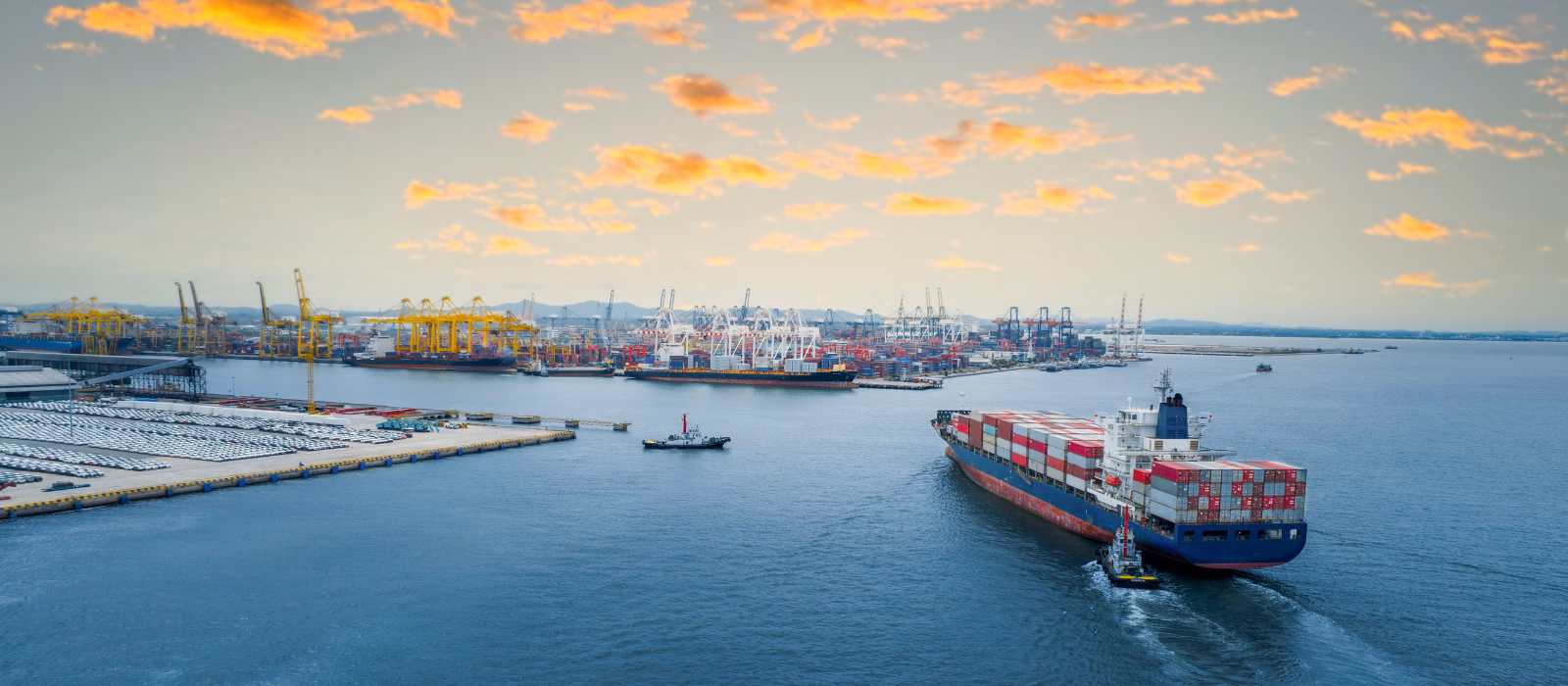
Remote Sensing
What is Remote Sensing?
Remote sensing is the process of collecting information about an object, area, or phenomenon from a distance, typically using satellite or airborne sensors. Instead of measuring directly on the ground, remote sensing captures imagery and data through electromagnetic signals, often using technologies like synthetic aperture radar (SAR), electro-optical (EO) sensors, and radio frequency (RF) signals.
In the maritime domain, remote sensing provides critical visibility across the oceans by detecting vessel movements, monitoring port activity, identifying environmental changes, and uncovering behaviors that might not be visible via traditional data sources like Automatic Identification Systems (AIS). Combined with artificial intelligence and advanced analytics, remote sensing helps transform raw satellite data into clear insights that support real-world maritime operations.
Key Takeaways
- Remote sensing refers to the collection of data about Earth’s surface from a distance, typically using satellites equipped with sensors like SAR, EO, and RF.
- In the maritime domain, remote sensing supports vessel detection, dark activity tracking, port monitoring, and environmental observation.
- AI and multi-sensor fusion transform satellite imagery into usable maritime intelligence, improving accuracy, context, and decision-making.
- Remote sensing is critical for national security, sanctions compliance, supply chain visibility, and trading decisions.
- Windward’s Remote Sensing Intelligence platform integrates satellite data with behavioral analytics and AIS to deliver actionable insights, from ship-to-ship transfer detection to infrastructure protection.
Why Remote Sensing Is Essential to Maritime Intelligence Systems
Modern maritime intelligence systems rely on remote sensing as a foundational data layer. By combining satellite imagery (SAR, EO) and RF signals with AIS and behavioral analytics, remote sensing provides unmatched visibility into vessel movements, activity patterns, and operational risk, even when AIS is spoofed or disabled.
Remote sensing intelligence strengthens core capabilities within maritime technologies, including:
- Vessel detection and tracking: SAR and EO imagery help detect vessels even when AIS is off, enabling persistent visibility across open ocean and coastal areas.
- Anomaly and pattern detection: By fusing satellite data with behavioral analytics, remote sensing helps identify unusual activity like loitering, dark STS transfers, or restricted zone entry.
- ETA forecasting and route monitoring: Satellite-based port and transit monitoring improves predictive models, supporting smarter routing and disruption response.
- Risk scoring and alerts: Integrated visual confirmation enhances risk scoring accuracy, validating behaviors like spoofing, unauthorized STS transfers, or suspicious trajectories.
- Infrastructure and zone monitoring: Remote sensing supports continuous surveillance of offshore platforms, undersea cables, and exclusion zones, with change detection and alerting.
Remote sensing has become a foundational layer in maritime technology, providing real-time visibility, behavioral insight, and operational precision. By enhancing core systems like tracking, forecasting, and anomaly detection, it turns satellite imagery into a strategic asset, supporting everything from day-to-day logistics to high-stakes decision-making at sea.
What is remote sensing intelligence, and how does it work in the maritime domain?
Remote sensing intelligence refers to the integration of satellite data with behavioral models and contextual maritime data to create actionable insights. In practice, this means combining SAR, EO, and RF data with AIS signals, vessel tracks, and risk indicators to detect anomalies, monitor patterns, and validate maritime activity in near real time.
What are the different types of satellite imagery used in maritime monitoring?
Remote sensing in the maritime domain relies on several key satellite imagery types, each offering unique advantages depending on the operational need:
- Synthetic Aperture Radar (SAR): Penetrates clouds and darkness to capture vessel activity in any weather, making it essential for 24/7 monitoring.
- Electro-Optical (EO): Provides high-resolution visual imagery, useful for confirming vessel types, activities, or infrastructure changes.
- Radio Frequency (RF) signals: Detects and locates electronic emissions from vessels, including those operating without AIS, enabling signal-based identification and tracking.
Together, these imagery types create a layered view of maritime activity.
How can AI make remote sensing data more accurate and actionable for maritime operations?
AI helps classify vessels, detect ship-to-ship transfers, flag unusual behaviors, and identify dark activity, even when vessels manipulate their location signals. Instead of requiring analysts to manually review satellite images, AI models extract relevant signals from large datasets, making insights more timely, targeted, and scalable across entire regions.
What is multi-sensor fusion, and why does it matter for maritime intelligence?
Multi-sensor fusion is the process of integrating SAR, EO, RF, and AIS data into one operational picture. This matters because each sensor type has strengths and limitations. Therefore, combining them reduces blind spots, increases accuracy, and enhances the reliability of alerts or detections. For example, RF may detect a vessel’s presence even if it appears “dark” in AIS, and SAR can confirm its location despite weather conditions.
How does remote sensing complement AIS data for vessel detection?
AIS provides a self-reported location, which can be manipulated or disabled. Remote sensing independently verifies vessel positions using satellite detections. When used together, AIS and remote sensing offer a reliable way to track movements, identify deception, and maintain maritime awareness across the globe.
How Remote Sensing Powers Maritime Surveillance and Defense Operations
For defense, coast guard, and enforcement agencies, remote sensing delivers persistent awareness across vast maritime domains. Unlike conventional patrols or radar systems, satellite-based surveillance provides consistent visibility in all weather conditions, across international waters, and in areas where physical coverage is limited.
By fusing SAR, EO, RF signals, and AIS data, remote sensing enables real-time detection of vessels attempting to operate covertly, whether by disabling transponders, loitering near sensitive zones, or conducting unauthorized operations.
Remote sensing enhances national security by supporting:
- Dark vessel detection and classification: SAR and RF data help detect and identify vessels operating without AIS or using deceptive tactics such as spoofing or flag hopping.
- Illegal, unreported, and unregulated (IUU) fishing enforcement: Satellite imagery combined with vessel behavior models helps pinpoint fishing activity in restricted areas and track repeat offenders.
- Border surveillance and smuggling prevention: Continuous wide-area monitoring detects small craft and unusual vessel movements across maritime borders, aiding interdiction and deterrence.
- Infrastructure and exclusion zone monitoring: Remote sensing detects loitering vessels, unauthorized construction, or potential threats near pipelines, cables, or offshore energy assets.
- Situational awareness and mission planning: Historical and real-time satellite imagery supports strategic planning and operational decision-making across agencies.
With the ability to cue imagery collections, detect behavior anomalies, and verify vessel presence independently of AIS, remote sensing intelligence equips defense and government teams with timely, trustworthy insight to secure their maritime borders and act with confidence.
How is remote sensing used for maritime surveillance and national security?
Remote sensing enables persistent surveillance over large maritime areas without deploying physical assets. By combining SAR, EO, and RF satellite data with AIS and behavioral analytics, agencies can detect and monitor vessels, including those trying to hide, in real time. This supports border control, military operations, smuggling interdiction, and early threat detection.
How does remote sensing detect dark vessels or illegal activity at sea?
Dark vessels disable AIS or manipulate their signals to avoid detection. Remote sensing overcomes this by using SAR (which works in all weather and light conditions) and RF sensors (which detect electronic emissions). These detections are then analyzed using AI to identify patterns such as loitering, unauthorized entry, or rendezvous events typical of smuggling, trafficking, or espionage.
What is the difference between SAR and EO imagery for defense applications?
- SAR (Synthetic Aperture Radar) captures images using radar signals, allowing visibility through clouds, darkness, and rough weather, making it ideal for 24/7 surveillance.
- EO (Electro-Optical) imagery provides high-resolution visual data, useful for confirming vessel type, observing structural details, and identifying activity patterns in clear conditions.
Used together, they create a layered, complementary view of the maritime environment.
How do agencies use remote sensing to monitor borders or maritime infrastructure?
Remote sensing supports daily or on-demand monitoring of sensitive zones, such as maritime borders, exclusion areas, and undersea infrastructure. AI-powered change detection and movement analysis help identify unauthorized access, suspicious loitering, or new construction, enabling faster response and long-term risk tracking.
Can remote sensing help identify illegal fishing or smuggling?
Yes. Remote sensing detects IUU fishing by identifying vessel movements in protected zones, analyzing loitering or gear-deployment behavior, and cross-referencing vessel identities. It also helps track smuggling by spotting small craft, detecting rendezvous at sea, or flagging suspicious behaviors that deviate from typical shipping routes.
Remote Sensing in Global Trade and Shipping
In the world of global trade and shipping, visibility is everything. Remote sensing adds a layer of independent verification to vessel movements, cargo transfers, and trade routes, providing traders, operators, insurers, and compliance teams with the proof they need to manage risk, verify documentation, and ensure contractual and regulatory alignment.
Traditional data sources like AIS and Bills of Lading (BoL) can be incomplete or manipulated. Remote sensing intelligence – powered by synthetic aperture radar (SAR), electro-optical (EO) imagery, and radio frequency (RF) signals – helps uncover the true story behind every shipment. By visually confirming vessel positions, detecting deceptive shipping practices like dark ship-to-ship transfers, and monitoring cargo flows at sea and in port, remote sensing enables smarter, safer trading decisions.
Whether used to validate Certificates of Origin (COO), monitor sanctioned entities, or assess energy and commodity flows, remote sensing transforms satellite data into a vital tool for trade transparency, contract enforcement, and operational awareness.
How is remote sensing used in global trade and shipping?
Remote sensing provides traders and shipping stakeholders with independent, verifiable visibility into maritime operations. By combining satellite imagery (SAR, EO) with RF and AIS data, remote sensing supports everything from cargo verification to dark activity detection. This enables better market forecasting, risk mitigation, and operational compliance across trade lanes.
How can satellite imagery verify cargo origins or detect sanctions evasion?
Satellite-based remote sensing confirms vessel locations and behavioral patterns that support cargo provenance claims. For example, if a ship claims to have loaded cargo in one location, but imagery or RF data shows a different route or an undeclared port call, that raises a red flag. Similarly, SAR and EO can visually confirm ship-to-ship transfers and route deviations associated with sanctions evasion or smuggling.
What role does remote sensing play in monitoring ship-to-ship (STS) strangers?
Dark STS transfers are often used to conceal the true origin or destination of cargo. Remote sensing detects and classifies these events, even when AIS is disabled, by analyzing vessel proximity, loitering behavior, and visual patterns. Windward’s platform, for example, uses AI to automatically pair vessels, estimate cargo volume transfers, and flag high-risk STS activity in regions known for sanctions evasion.
How do traders use remote sensing to assess market supply and flows?
Commodity traders monitor tanker movements, port congestion, and stockpile volumes using remote sensing. High-resolution SAR and EO imagery help track supply flows of crude oil, LNG, coal, and grain, while RF signals can identify additional vessel activity not visible via AIS. These insights shape trading strategy by revealing actual shipment volumes and potential delays.
Can remote sensing data support compliance in trade finance?
Yes. Trade finance teams use remote sensing intelligence to verify that shipments align with documentation. By confirming vessel behavior, port calls, and STS events, satellite imagery supports Know Your Vessel (KYV™) processes and mitigates fraud risk. Windward’s platform integrates these insights directly into trade finance workflows to accelerate compliance decisions and reduce exposure.
Using Remote Sensing to Optimize Container Logistics
In global supply chains, visibility is everything – and remote sensing offers a clearer view of port and vessel activity than AIS alone. By layering satellite imagery (SAR and EO) with predictive analytics and RF signals, logistics teams can track congestion, vessel movements, and throughput in near real time.
This visibility supports smarter planning and faster decision-making across key areas:
- Port congestion monitoring: SAR and EO imagery track vessel queues, anchorage zones, and terminal operations, giving logistics teams an accurate picture of wait times and capacity constraints.
- Container throughput analysis: AI-powered object detection identifies and counts containers in storage yards and on vessels, helping optimize yard management and predict delays.
- ETA forecasting and disruption response: Satellite-based insights enrich predictive models with visual proof of delays, reroutes, or idle periods, improving ETA accuracy and enabling rapid response to disruptions.
- Route optimization: Real-time activity monitoring supports proactive re-routing to less congested ports or terminals when anomalies are detected.
As logistics operations grow more complex, remote sensing ensures that shipping decisions are based on ground-truth visibility, not guesswork.
How does remote sensing improve port monitoring and congestion management?
Remote sensing provides near real-time visibility into vessel traffic, anchorage congestion, and terminal operations using SAR and EO satellite imagery. This allows logistics teams to assess delays, optimize port calls, and anticipate bottlenecks with higher accuracy than AIS-based tracking alone.
Can satellite imagery track container volumes and vessel movements in real time?
Yes. AI models applied to high-resolution optical imagery can detect and count containers in port storage areas, on vessels, and during loading or unloading operations. Combined with vessel detection from SAR and RF signals, remote sensing creates a comprehensive, real-time operational view.
How can remote sensing data enhance supply chain visibility?
By integrating satellite imagery with predictive analytics and vessel tracking data, remote sensing closes visibility gaps, especially when AIS is disabled or spoofed. It enables early detection of disruptions, supports rerouting decisions, and improves coordination across stakeholders.
How do logistics teams use remote sensing insights for ETA prediction and disruption management?
Remote sensing adds a layer of validation to ETA models by showing actual vessel location, speed, and port activity, even during AIS outages. This helps refine forecasts, trigger alerts for unexpected delays, and improve communication with customers and partners.
Windward’s Remote Sensing Intelligence: From Detection to Decision
Windward’s Remote Sensing Intelligence solution was purpose-built to meet the growing demand for contextual, explainable maritime satellite intelligence. By fusing multi-sensor satellite data (SAR, EO, RF) with behavioral analytics and AIS tracking, the platform delivers structured, operational insights to support security, trade, compliance, and logistics decisions.
What Makes Windward’s Remote Sensing Intelligence Different?
- Multi-Sensor fusion in one platform: Windward integrates synthetic aperture radar (SAR), electro-optical (EO), and radio frequency (RF) data with proprietary AI models and AIS analysis. This fusion enables consistent visibility, even when traditional tracking signals are unavailable.
- AI-based behavioral analytics: Our platform detects vessels and understands their behavior. Windward applies AI to flag anomalous actions like dark STS transfers, loitering, or course deviations, giving users insight into not just what happened, but why it matters.
- Integrated tasking and investigation: Users can task new SAR, EO, or RF collections directly within the Windward platform. All collections, including customer-uploaded imagery, are stored, annotated, and linked to investigations for long-term case building and collaboration.
- Built-in compliance and security workflows: From sanctions screening to border security and port monitoring, Windward’s solution is embedded into existing workflows. Risk scores, alerts, and visual confirmations help users act faster with greater confidence.
- Proven accuracy and global coverage: Windward’s models detect dark STS events with 94% accuracy and flag spoofed AIS activity with 75% fewer false positives than other providers. Coverage includes high-risk regions across Asia, Africa, the Middle East, and the Americas.

Solution Highlights by Use Case
| Use Case | Windward Advantage |
| Dark Vessel Detection | Detect AIS-off activity using SAR and RF – classifies vessel type and movement. |
| STS Transfer Monitoring | Automatically identifies vessel pairings, transfer duration, and sanctions risk. |
| Oil Spill Response | Rapid SAR-based detection with 84-hour spill trajectory forecasting. |
| Port Activity Monitoring | Tracks vessel density, wait times, and container volumes with 90% detection accuracy. |
| Insurance Protection | Monitors offshore platforms, pipelines, and undersea cables with change detection. |
How is Windward’s approach different from traditional satellite image providers?
While other solutions deliver raw imagery, Windward transforms it into intelligence. We contextualize each image with AI-powered behavior analysis, vessel history, and risk scoring, reducing the need for expert interpretation or external tools.
Can I upload and analyze my own imagery in Windward’s platform?
Yes. Windward’s “Bring Your Own Imagery” (BYOI) feature allows users to upload SAR or EO images, which are automatically enhanced with detections, behavioral overlays, and contextual data, all within a unified investigation environment.
How quickly can I get results after tasking new imagery?
Tasking latency depends on the satellite provider, typically ranging from 4 to 8 hours. Once imagery is downlinked, Windward’s models process it in-platform, linking detections to vessels, events, and risk factors in near real time.
Does Windward support trade finance compliance and sanctions checks?
Absolutely. Financial institutions use Windward to verify cargo provenance, screen vessels for spoofing or sanctions violations, and reduce false positives in compliance workflows. Our solution integrates with trade finance platforms to streamline KYC, AML, and payment approval checks.
Explore more

The Suez Canal
What Is the Suez Canal? The Suez Canal is a 193-kilometer (120-mile) artificial waterway in Egypt that connects the Mediterranean Sea at Port Said to the Red Sea at Suez, providing the only direct maritime route between Europe and Asia without circumnavigating Africa. The canal runs north-to-south across the Isthmus of Suez, crossing several natural...
Read more

Barnacles
What Are Barnacles? Barnacles are small marine crustaceans that permanently cement themselves to hard surfaces underwater, including the hulls, propellers, and sea chests of ships. Once attached, they form rough, calcified colonies that disrupt the smooth flow of water along a vessel’s hull, increasing hydrodynamic drag and forcing the engine to burn more fuel to...
Read more

EMCON (Emissions Control)
What Is EMCON? EMCON, short for emissions control, is the naval discipline of deliberately silencing or restricting a ship, submarine, aircraft, or task force’s electromagnetic emissions to avoid detection. Under EMCON, units shut down or limit radar, radio, AIS, IFF, and other emitters while still receiving outside signals, turning a vessel that is physically present...
Read more

Decision Intelligence
What Is Decision Intelligence? Decision intelligence is the discipline of combining data, analytics, and artificial intelligence to support better human decision-making in complex, high-stakes environments. It goes beyond traditional business intelligence — which focuses on reporting what has happened — by modeling causes, predicting outcomes, and recommending actions, while keeping the human decision-maker in the...
Read more

Territorial Waters
What Are Territorial Waters? Territorial waters are the belt of sea extending up to 12 nautical miles from a coastal state’s baseline, over which that state exercises sovereignty subject to the rules of international law. Within this zone, the coastal state has full legal authority over the water, seabed, subsoil, and airspace above, with the...
Read more