Whitepapers

The Short Blanket Conundrum: Maritime Intelligence in a Vast Domain

What’s inside?

    Maritime security operates under a permanent constraint: the domain is vast, resources are finite, and exposure is unavoidable.

    At the same time, agencies are being asked to do more with less – more missions, more complexity, more political and operational consequences – without a proportional increase in assets, personnel, or time.

    The maritime domain has become persistently volatile. Sanctions enforcement, irregular migration, gray-zone competition, and illicit trade now overlap in the same waters. Events escalate faster, and ambiguity is deliberate. At the same time, patrol fleets, aerial assets, and analytic teams remain finite.

    The result is a constant operational tension: every deployment decision creates risk elsewhere. This challenge can be described as the short blanket conundrum.

    The Short Blanket Conundrum at Sea

    The short blanket conundrum describes the reality of operating in a domain that is too large to fully cover with the resources available. No matter how the blanket is positioned, some part remains exposed. Pull it one way, and something else is uncovered.

    At sea, this is not a metaphor, but rather a daily operational dilemma. Sending a patrol cutter, tasking satellite imagery, or launching a UAV to one area means another area is left unattended. There is no configuration that eliminates exposure; there are only choices about where exposure is acceptable.

    For maritime enforcement and defense agencies, the question is not whether gaps will exist. They always will. The critical question is whether those gaps are the result of deliberate, informed decisions or of incomplete understanding.

    The purpose of maritime intelligence in this environment is not to remove risk. It is to place limited resources where they matter most, while continuously monitoring the areas that cannot be physically covered.

    Why Maritime Coverage Always Falls Short

    The maritime domain breaks traditional coverage models because of its scale.

    The U.S. Coast Guard alone is responsible for more than 5,000 miles of coastline, 25,000 miles of navigable inland waterways, and a 200-mile EEZ. In total, this amounts to jurisdiction over more than 4.5 million square miles of ocean.

    That area is monitored and enforced by a fleet of roughly 250 cutters and 1,600 smaller boats, operating across search and rescue, law enforcement, border security, and national defense missions. Even without accounting for maintenance cycles, crew availability, weather, or competing priorities, the math is unforgiving. Each asset is responsible for thousands of square miles at any given moment.

    In larger theaters, the imbalance becomes even more pronounced. U.S. Indo-Pacific Command spans roughly 100 million square miles, representing more than half of the Earth’s surface. No force structure can cover that space in any traditional sense.

    As a result, maritime operations are not about omnipresence. They are about probability:

    • Probability of detection.
    • Probability of interdiction.
    • Probability that the next threat emerges where assets are not.

    Every deployment is a tradeoff.

    The Cost of Getting It Wrong

    Misallocating maritime assets carries real and compounding costs.

    Sending a patrol cutter to the wrong location is not simply fuel burned and crew hours expended. It is time during which another area remains unobserved. It is deferred maintenance. It is crew fatigue. It is lost opportunity elsewhere in the domain.

    The same applies to satellite tasking and UAV deployments. These are not free checks. They consume limited collection capacity, analyst attention, and time. When those resources are spent investigating routine or irrelevant activity, the cost is not just inefficiency; it’s increased exposure elsewhere.

    In recent years, dark fleet activity in the Caribbean linked to sanctions evasion has illustrated this risk clearly. Deploying assets based on incomplete or misleading signals can pull enforcement attention away from adjacent corridors where activity is actually escalating.

    The worst outcome is not missing activity outright, but rather deploying confidently to the wrong place, while a higher-risk event develops unnoticed somewhere else.

    Why Traditional Maritime Intelligence Struggles

    Several structural barriers make precision difficult.

    Tactical obscurity allows actors to exploit darkness, AIS manipulation, flag hopping, and ambiguous routing to mask intent. Cooperative signals alone are no longer reliable.

    Strategic asset inefficiency emerges when limited platforms are spread thin in an attempt to “cover more,” reducing detection probability everywhere.

    Intelligence latency results from manual coordination between data sources, imagery providers, and analytic teams, undermining continuous awareness.

    Finally, analyst saturation places too much cognitive burden on too few people, increasing the risk of both false alarms and missed escalation.

    Together, these barriers make it difficult to answer the most important operational question: Where should attention be focused right now?

    Knowing What’s Happening Without Acting Yet

    The first step in addressing the short blanket conundrum is continuous awareness.

    No human team can monitor the entire maritime domain at all times. AI-driven systems can. 

    By continuously scanning large areas for deviations in vessel behavior – such as AIS gaps, unusual loitering, unexpected course changes, or atypical port interactions – AI establishes a living baseline of what “normal” looks like across regions and seasons.

    This monitoring operates at the population level. Instead of focusing on individual vessels in isolation, AI evaluates how entire groups of vessels behave within defined areas. When aggregated behavior shifts, it signals that something in the environment may be changing.

    For example, Windward’s Early Detection capability establishes behavioral baselines for vessel populations across specific regions and time periods, identifying statistically significant deviations from expected patterns. This allows agencies to surface emerging risk trends that would remain invisible through single-vessel monitoring alone.

    At this stage, no decisions are made, and no assets are deployed. The objective is awareness without commitment, and maintaining visibility over areas that are not actively covered by patrol presence.

    This passive, continuous monitoring effectively stretches the blanket by reducing uncertainty in uncovered spaces.

    Contextualized Alert: An anomaly is surfaced after autonomous investigation, already enriched with behavioral context, historical comparison, and risk layers.
    Contextualized Alert: An anomaly is surfaced after autonomous investigation, already enriched with behavioral context, historical comparison, and risk layers.

    Understanding What Actually Matters

    Continuous awareness produces a high volume of signals. That is a strength, but it also creates a practical limit. Even well-staffed analytics teams cannot continuously scan, contextualize, and prioritize every deviation across a vast maritime domain in real time.

    Agentic AI systems now perform autonomous investigations before escalating to human analysts. Instead of flagging every deviation, these systems:

    • Compare current behavior to historical patterns.
    • Cross-reference risk indicators.
    • Identify whether the activity represents routine operations or a meaningful change.

    Only when a deviation is assessed as significant does it reach an analyst.

    At Windward, this investigative logic is trained on workflows derived from more than 15,000 high-stakes maritime intelligence reports produced by expert analysts over years of operational use. Instead of surfacing raw alerts, the system executes multi-step investigative reasoning before escalation, replicating the judgment patterns of experienced maritime analysts at scale.

    This shifts the analyst’s role from gathering data to evaluating meaning. Human attention is reserved for events that represent potential operational or strategic risk.

    This step is about deciding what deserves attention, not about gaining additional visibility yet.

    Gaining Visibility Without Deploying Assets

    Once an event is assessed as potentially meaningful, the next challenge is visibility.

    Deploying a patrol cutter or UAV immediately is costly and slow, particularly when the area of interest is far from the nearest asset. Instead, Remote Sensing Intelligence enables graduated escalation.

    SAR Confirmation: SAR imagery confirms vessel presence and behavior in the area of interest, including semidark or dark interactions, regardless of weather or time of day.
    SAR Confirmation: SAR imagery confirms vessel presence and behavior in the area of interest, including semidark or dark interactions, regardless of weather or time of day.

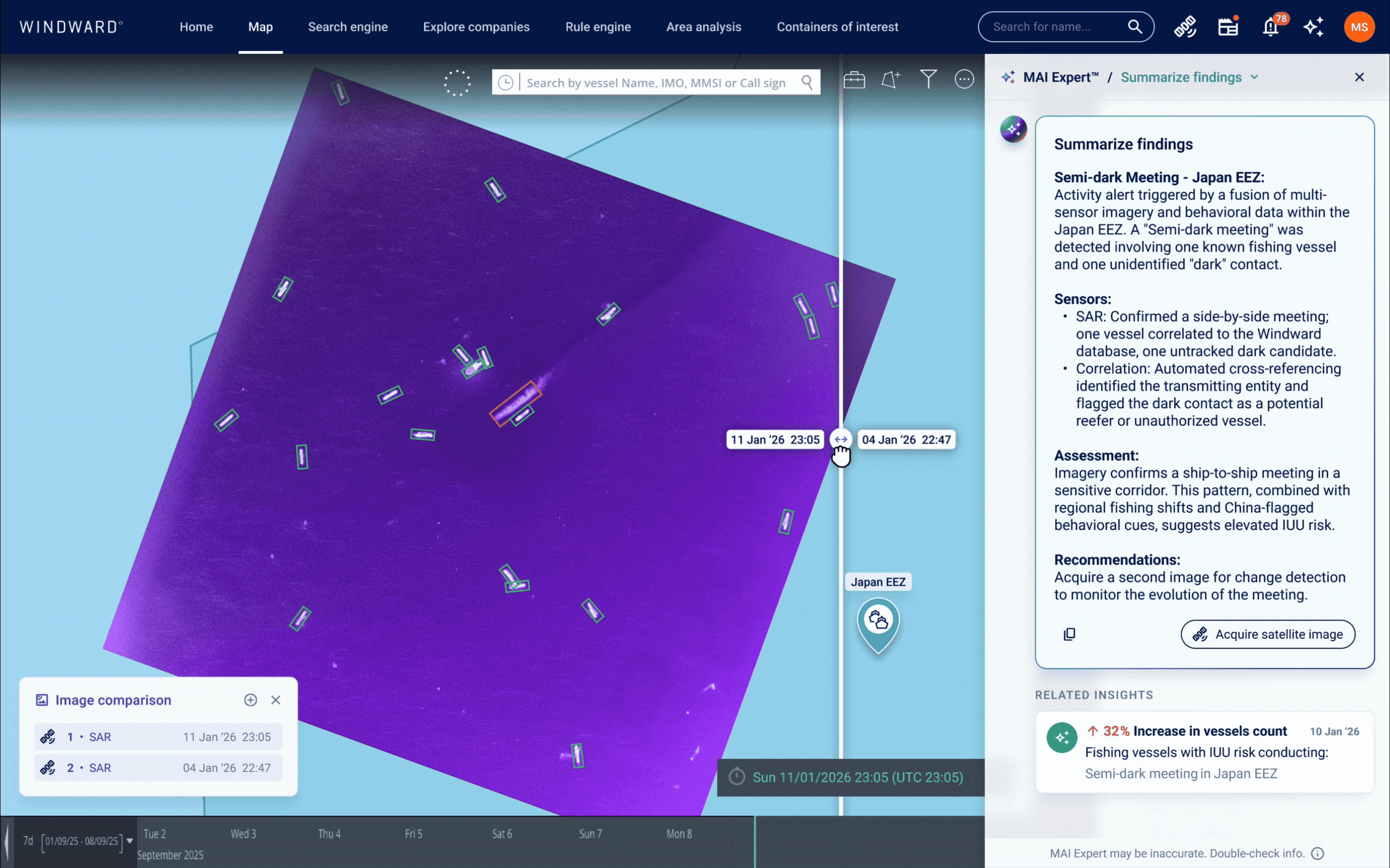
    Synthetic aperture radar (SAR) imagery, one type of satellite imagery, provides persistent, weather-independent visibility, often with greater consistency than physical patrols. Analysts can confirm whether suspected activity is actually occurring and identify additional vessels in the vicinity, rather than relying solely on AIS, a cooperative, self-reported signal that is frequently absent, degraded, or manipulated by bad actors.

    Within Windward’s platform, this remote sensing workflow is integrated directly into the investigative process, allowing analysts to task, analyze, and compare imagery without leaving the operational context of the case.

    AI-Based Change Detection: Temporal analysis compares current imagery to prior collection, revealing a clear buildup of vessels over time and establishing a pattern rather than a single snapshot.
    AI-Based Change Detection: Temporal analysis compares current imagery to prior collection, revealing a clear buildup of vessels over time and establishing a pattern rather than a single snapshot.

    By analyzing imagery over time, AI-driven change detection transforms isolated observations into a narrative. Analysts can determine whether activity is escalating, stabilizing, or dissipating without deploying a single physical asset.

    At this point, agencies move from assessment to evidence.

    Acting with Confidence When Action Is Required

    When a decision to act is made, it is no longer speculative.

    By this point, analysts have:

    • Detected anomalous behavior.
    • Investigated its context.
    • Confirmed activity visually.
    • Established temporal patterns.
    Mission Planning and Orchestration: From within a single platform, analysts define patrol areas, coordinate multi-sensor collection, and maintain visibility throughout mission execution.
    Mission Planning and Orchestration: From within a single platform, analysts define patrol areas, coordinate multi-sensor collection, and maintain visibility throughout mission execution.

    In Windward’s platform, this workflow occurs within a single operational environment. Analysts do not move between disconnected systems, task imagery in isolation, or manually reconcile findings across tools. Eliminating platform switching reduces latency, preserves analytical context, and accelerates decision-making.

    Importantly, physical assets are now deployed with a clear purpose and supporting intelligence artifacts. Time spent in transit is no longer blind time. Visibility continues through remote sensing and monitoring.

    This is where limited resources are used deliberately, not defensively.

    Decision Advantage Under Constraint

    The blanket never becomes large enough to cover everything. That reality does not change.

    What does change is how exposure is managed.

    For maritime agencies operating under persistent pressure – from sanctions enforcement and border security to gray-zone competition – decision advantage comes from knowing where to apply limited resources and where to accept risk deliberately.

    With continuous awareness, autonomous investigation, graduated visibility, and intelligence-driven deployment, agencies gain a decision advantage. They reduce wasted missions, shorten response timelines, and make risk acceptance explicit rather than accidental.

    Exposure becomes strategic instead of arbitrary.

    In an environment defined by persistent ambiguity and limited assets, the ability to decide where to act, when to act, and where not to act is the defining advantage of modern maritime intelligence.

    See How This Decision Model Works in Practice