


March 26, 2026
Maritime Terms Explained: The Iran War & Strait of Hormuz Crisis


GPS Jamming is Now a Mainstream Maritime Threat
What’s inside?
At a Glance
- GPS jamming accelerated across the global fleet in 2025, evolving from a contained threat to a widespread operational disruptor affecting trade, enforcement, and compliance.
- In Q1, new spoofing hubs emerged and AIS jumps exceeded 6,000 km, pointing to more coordinated and deliberate interference.
- By Q2, GPS jamming surged, impacting over 13,000 vessels, with geopolitical flashpoints like the Iran conflict driving mass spoofing events and false port calls.
- In Q3, spoofing became routine across 27 EEZs, with growing overlap between GPS jamming and other deceptive shipping practices like flag hopping and identity laundering.
- Looking to 2026, the focus must shift from detection to resilience, with systems that can decode deceptive data and drive action when visibility is compromised.
What Three Quarters of GPS Jamming Reveal About Maritime Risk
In 2025, GPS jamming became maritime’s fastest-growing and most disruptive operational challenges.
What began as concentrated interference in a few high risk zones quickly escalated into a global-scale disruption with thousands of vessels broadcasting false locations and incidents reported in every major trade region.
As the year progressed, the signals grew bolder, the targets more strategic, and the operational fallout more widespread. Due diligence was compromised. Enforcement delayed. Operations were disrupted, often in real time.
And there’s no sign of slowing down.
This blog unpacks the evolution of GPS jamming across Q1, Q2, and Q3 2025, and what the patterns say about the maritime risk environment heading into 2026.
Q1: From Interference to Pattern
At the start of 2025, GPS jamming wasn’t new, but the nature and behavior of the signals shifted in ways that pointed to a broader, more coordinated threat.
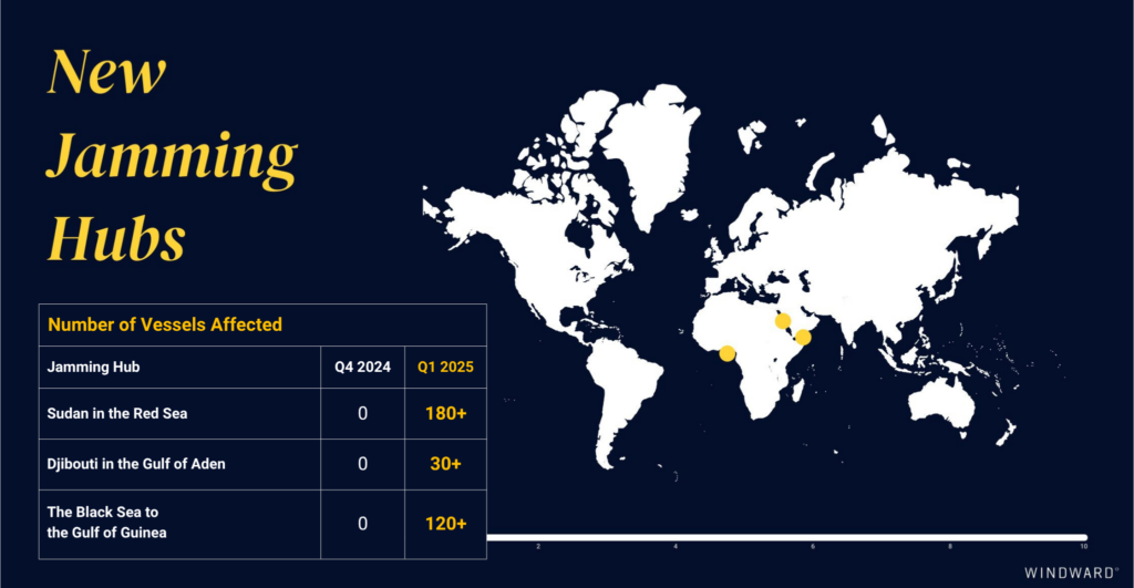
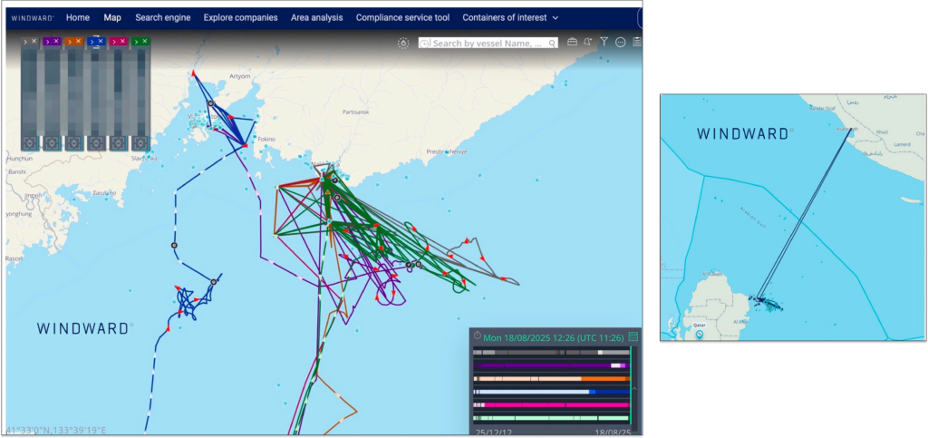
AIS jumps that previously averaged 600 kilometers suddenly exceeded 6,300 kilometers, introducing new levels of risk for both real-time decision-making and post-event investigations. At the same time, three new jamming hubs emerged – in Sudan, Djibouti, and the Black Sea–Gulf of Guinea corridor – marking a geographic expansion beyond previously monitored zones.
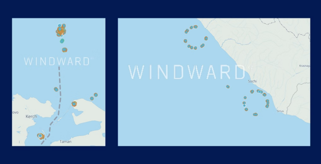
Equally notable was the shift in spoofing behavior. Instead of the dense, circular signal loops that characterized earlier incidents (in Q4 2024), Windward observed larger, defined spoofing zones and straight-line anomalies, designed to confuse tracking systems and obscure vessel behavior.
The ripple effects were immediate. GPS spoofing disrupted port entrances, rerouted cargo, and reduced situational awareness, directly impacting trade operations and undermining maritime safety protocols.
Q2: GPS Jamming Goes Global
In Q2, GPS jamming escalated dramatically, both in volume and in visibility. While spoofing events in Q1 were mostly isolated, the second quarter saw a sharp shift in scale. Clusters of spoofed vessels began appearing simultaneously across multiple regions, with longer spoofing durations and wider jumps indicating a more synchronized, deliberate pattern.
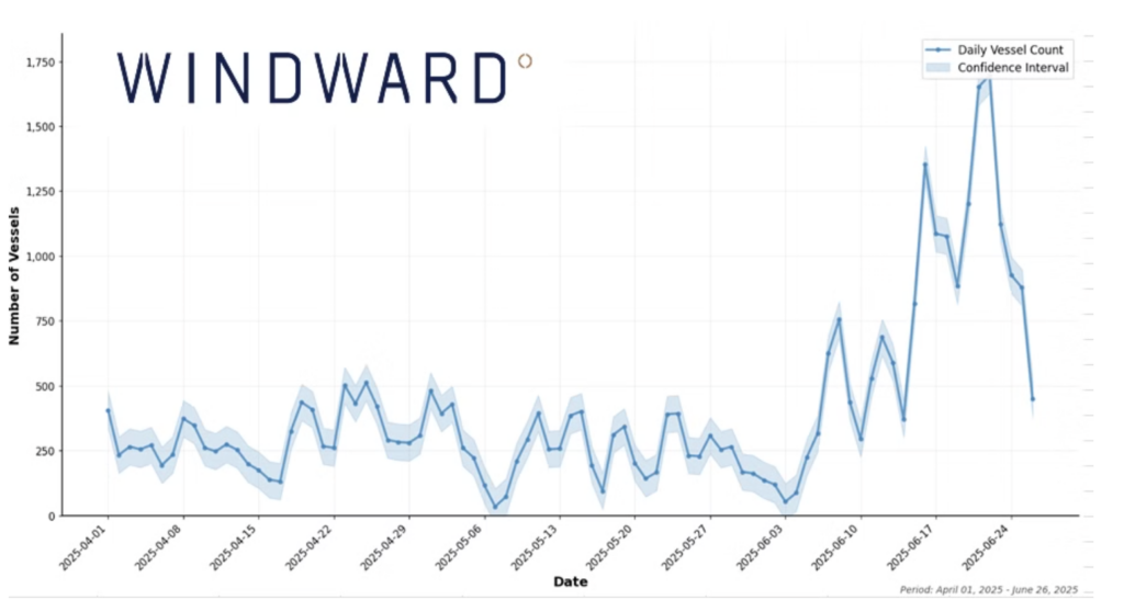
More than 13,000 vessels were impacted globally during the quarter, with new hotspots emerging in the Arabian Gulf, Mediterranean, and Baltic regions. But the biggest disruption came from the Iran conflict, which triggered a jamming supercluster in the Eastern Mediterranean.
Between June 13 and June 24, more than 12,000 spoofing incidents were recorded, impacting over 3,000 vessels worldwide. Of the vessels affected, 97% “jumped” onto land, generating false port calls in Iran and triggering screening alerts across multiple systems.
This wasn’t just a technical anomaly. Due diligence workflows failed, enforcement actions were delayed, and routine screening tools flooded users with false positives, obscuring actual high risk behavior.
By the end of Q2, GPS jamming had evolved into a global challenge to maritime transparency, undermining visibility, trust, and enforcement and infrastructure scale.
Q3: A Normalized Threat with Complex Layers
By Q3, GPS jamming had become a daily operational reality, not an outlier event.
Windward detected spoofing activity in 27 different Exclusive Economic Zones (EEZs), with signals recorded across every major trade region. More than 11,600 vessels were affected globally, with a new hotspot emerging near Nakhodka Bay and the Kozmino oil terminal – a key Russian energy export hub in the Far East. While slightly fewer vessels were impacted than in Q2, the scale still marked a 510% increase over Q1, confirming a long-term trajectory rather than a temporary spike.\
Spoofing now routinely targets sensitive port zones, chokepoints, and enforcement-heavy jurisdictions, complicating due diligence and increasing the risk of misidentifying high risk behavior.
More critically, Q3 revealed deepening overlaps between spoofing and other deceptive shipping practices (DSPs). Vessels engaged in identity laundering, flag hopping, and false port calls frequently exhibited spoofed positions, creating layered anomalies that blurred the line between error and intent.
Illicit activity was increasingly masked by background noise, leaving compliance, intelligence, and security teams struggling to isolate real threats in a sea of false signals.
Three Quarters In: What the Patterns Say
When viewed across Q1–Q3, the trajectory of GPS jamming has become undeniable and deeply operational:
- Scale: From a few hundred spoofed jumps in Q1 to over 13,000 vessels impacted in Q2 and Q3.
- Spread: From three jamming hubs to more than 10 global hotspots across four continents.
- Proximity: From regional interference to routine disruption near oil terminals, trade corridors, and enforcement zones.
- Side Effects: False port calls, screening fatigue, and real violations hidden by noise.
Each quarter in 2025 brought a measurable shift. In Q1, spoofing behavior became more strategic, targeting chokepoints and shifting signal patterns. Q2 marked a turning point, with widespread geographic expansion and mass spoofing events tied to geopolitical flashpoints. By Q3, jamming had normalized across the global fleet and often overlapped with other deceptive behaviors, making operational transparency harder to achieve.
This trendline suggests 2026 won’t bring stabilization – it will demand adaptation.
Organizations that rely on static screening, siloed enforcement, or manual workflows will fall behind. The next phase of risk management will require platforms that connect the dots automatically – across quarters, behaviors, and signals – to enable faster decisions when the data is designed to deceive.
The Way Forward: Building GPS Jamming Resilience
Windward’s analysis across Q1-Q3 shows that GPS jamming isn’t going away, but its impact can be managed.
Mitigation starts with real-time anomaly detection. But resilience requires a more strategic approach:
- Behavior-based risk modeling that analyzes vessel behavior over time to assess intent – even when location data is spoofed.
- AI-powered voyage and port call validation to automatically flag implausible stops and spoofed positions before they disrupt workflows.
- Explained, actionable risk signals that help operations, compliance, and intelligence teams act with confidence – even when the raw data is compromised.
Windward’s Maritime AI™ platform is purpose-built to help organizations cut through GPS jamming noise and focus on what matters most.
Whether you’re managing fleets, trade flows, or investigations, it’s time to shift from reacting to spoofing to building workflows that expect it.
Trending
- The EU’s 18th Sanctions Package Lookback Started. Trading Russian Products? You're At Risk. Nov 24, 2025
- Tanker Freight Rates Hit Five-Year High Amid Russian Oil Sanctions Shake-Out Nov 6, 2025
- Sanctioned, Stateless, and Still Sailing: Expert Insights from the Frontlines of Maritime Sanctions Nov 3, 2025
Explore more

Russia Expands Dark Fleet of LNG Carriers
At a Glance Covert Transfers and Reflagging Activity Three 20-year-old liquefied natural gas (LNG) carriers were recently sold to a newly formed company in Türkiye, with two subsequently reflagged to Sierra Leone, a ship registry favored by Russia’s dark fleet. All three LNG carriers have yet to signal their next destination to load a post-sale...
Read more

Distress or Deception? Sea Horse ‘Not Under Command’ While Delivering Cuba Gasoil
At a Glance Sea Horse, a medium range tanker sailing for Cuba laden with Russian gasoil has been broadcasting it is “not under command” and that it is drifting in the Sargasso Sea for nearly three weeks. AIS tracking suggest the Hong Kong-flagged tanker has now resumed its voyage for Cuba and is set is...
Read more

U.S. Treasury Expands Pressure on Iran’s Shadow Fleet and Weapons Procurement Networks
At a Glance Expanding Pressure on Iran’s Maritime and Weapons Networks On February 25, 2026, the U.S. Department of the Treasury’s Office of Foreign Assets Control (OFAC) designated more than 30 individuals, entities, and vessels linked to Iran’s shadow fleet and to networks supporting ballistic missile and advanced conventional weapons production. The action targets two...
Read more

The EU Maritime Services Ban That Didn’t Pass: Implications for Russian Trade
At a Glance A Sanctions Escalation That Stalled The European Union’s proposed maritime services ban on Russia was expected to mark a structural escalation in sanctions enforcement. Instead, EU ministers failed to reach an agreement, delaying the adoption of the bloc’s 20th sanctions package after opposition led by Hungary, with at least one other member...
Read more

Russian Diesel Tanker Sails for Cuba as U.S. Order Blocks Oil Imports
A tanker carrying Russian diesel is sailing for Cuba even as tightening U.S. pressure on the island’s fuel supply has forced other shipments to abort voyages or cancel loadings. Vessel Movements, AIS Changes, and Cargo Origin The Hong Kong-flagged medium-range tanker initially broadcast Havana as its destination on February 7, then altered its AIS signal...
Read more