


July 12, 2026
Iran Formally Closes the Strait of Hormuz as the U.S. Launches a Third Round of Strikes


New GPS Jamming Hotspot Seen at Third Russian Oil Export Port
What’s inside?
Windward has detected extensive GPS jamming in a new location at the eastern Russian port of Nakhodka, leading to a 30% rise in deliberate interference to ships’ navigation signals across the region over August.
Between August 5-18 the Automatic Identification Signals (AIS) of 112 ships were transmitted on land at Nadhodkta port, the first time GPS jamming was noted in this area.
The GPS jamming occurred across the bay from the Transneft export terminal at Kozmino, where crude is exported from the Eastern Siberia Pacific Ocean (ESPO) pipeline.
This marks the third major Russian oil hub to be hit by deliberate signal interference, with similar GPS jamming disruptions noted for protracted periods in the Baltic Sea around Ust Luga and Primorisk, as well as Novorossiysk in the Black Sea.


Significant interference with tanker AIS signals linked to GNSS manipulation was already seen around Kozmino before GPS jamming was detected at Nadhokta.
GPS jamming, which blocks ships’ AIS satellite signals, is a common tactic attributed to greyzone aggression to obscure maritime activity but is also a significant navigation hazard.
The tactic is different to GNSS manipulation, also known as spoofing, in which ships falsify their real AIS location in order to obfuscate their position. However both GPS jamming and GNSS manipulation add to difficulties tracking loading of oil by Russia-trading tankers.
Windward Detects Surge in Ships’ AIS Signal Interference Near Kozmino, Russia
Vessels off Russia’s eastern seaboard were previously observed undertaking widespread GNSS manipulation to conceal port loadings and ship-to-ship transfers. In addition to the 112 ships seen in GPS jamming areas, the signal of a further 154 ships in the eastern region were manipulated or interfered with in the first 18 days of August, according to Windward.

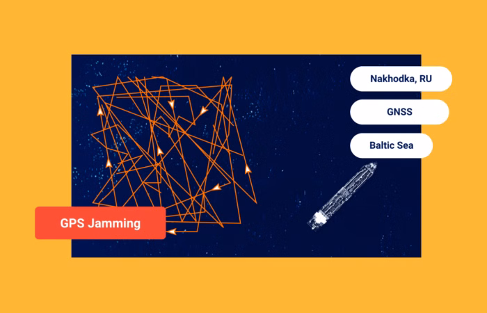
GPS jamming at Nadhokta (in red) first emerged on August 6, 2025.
The combined GPS jamming and location (GNSS) manipulation in Kozmino over August is 30% higher compared with the first 18 days of July, Windward research showed.The emergence of Kozmino as a GPS jamming hotspot underscores widespread deliberate strategy to conceal or manipulate vessel movements across Russia’s critical oil export zones.
Pervasive GPS Jamming Seen in Baltic and Black Seas
There are two zones noted in the Baltic Sea where GPS jamming diverts vessels’ AIS signals to land: around Kaliningrad’s port and near Primorsk. AIS signals from tankers calling at Ust Luga and Primorsk are diverted to waters off Finland, forming a ring.


Top: GPS jamming is diverting AIS signals of tankers in Russian waters around Ust Luga and Primorsk to Finland, to form a perfect circle. Bottom: GPS jamming is diverting signals to Kaliningrad as ships sail in the Baltic Sea.
Interference throughout the Black Sea has become pervasive, since Russia invaded Ukraine in 2022.
There’s also been severe disruption to navigation in the Red Sea since May because of GPS jamming, in coordination with increased attacks on commercial maritime traffic by Iran-sponsored Houthis.
GPS jamming has impacted nearly 1,000 ships a month in the Red Sea, with 600 affected so far in August, Windward analysis shows.

GPS jamming is seen in the Red Sea in waters off Sudan.
GPS jamming affected nearly 2,000 ships in the past 30 days in the four key regions identified by Windward. The biggest area of interference was in the Red Sea off Sudan (824 vessels), followed by the Black Sea (471 vessels), Baltic Sea (460 vessels), and Nadhokta (112 vessels).
Incidents of GPS jamming in the Strait of Hormuz and Arabian Gulf, which peaked at nearly 1,000 ships daily at the height of the Iran conflict have dropped dramatically, with less than a dozen detected this month.
Trending
- The EU’s 18th Sanctions Package Lookback Started. Trading Russian Products? You're At Risk. Nov 24, 2025
- Tanker Freight Rates Hit Five-Year High Amid Russian Oil Sanctions Shake-Out Nov 6, 2025
- Sanctioned, Stateless, and Still Sailing: Expert Insights from the Frontlines of Maritime Sanctions Nov 3, 2025
Explore more

H1 2026: The Moving Target of Maritime Sanctions Compliance
The first major maritime sanctions deadline of 2026 arrived on January 21, when the EU’s refined-products ban began applying to fuels produced in third countries from Russian crude. That deadline set the tone for the months that followed: more granular rules, more infrastructure-linked exposure, and more time-bound permissions that compliance teams need to track alongside...
Read more

What the New OFAC-OFSI Comparative Overview Means for Maritime Sanctions Compliance
At a Glance The OFAC-OFSI Publication in Context The U.S. Department of the Treasury’s Office of Foreign Assets Control (OFAC) and His Majesty’s Treasury’s Office of Financial Sanctions Implementation (OFSI) are the offices responsible for enforcing economic sanctions implemented by the United States and the United Kingdom, respectively. The two offices established the OFAC-OFSI Enhanced...
Read more

What Bunkering Operators Need to Know About the EU’s 21st Sanctions Package
At a Glance What the 21st Package Means for Bunkering The EU’s 21st sanctions package, proposed on June 9, 2026, introduces a structural shift in how Russia sanctions reach into the maritime services sector. Previous packages focused on sanctioning the vessels themselves, the entities operating them, and the financial institutions enabling the trade. The 21st...
Read more

GPS Jamming Is Breaking the AIS Data Compliance Teams Rely On
At a Glance The Compliance Problem That Did Not Exist Five Years Ago For two decades, AIS has served as the trusted backbone of maritime compliance screening. Banks screen counterparties using AIS-derived vessel histories. Insurers price policies and assess claims using AIS movement records. Charterers evaluate vessel KYC profiles using AIS-confirmed port call histories. Marine...
Read more

GPS Jamming Is Now a Mainstream Maritime Threat: What Changed Between 2025 and 2026
At a Glance What Changed Across 2025 and 2026 GPS jamming was not new before 2025. As a military and intelligence capability, it has existed for decades. What changed between 2025 and 2026 is the scale, geographic spread, and operational normalization of jamming events affecting global commercial shipping. The 2025 picture established that jamming had...
Read more