Guides

The Future of Tipping & Cueing: Automation is the Next Frontier

As coast guards continue to face an increasingly complex maritime domain, the next evolution in tipping and cueing is clear: automation. The traditional manual process — while effective in many scenarios — is often too slow, too reactive, and too dependent on individual skill and bandwidth. The future lies in leveraging AI-driven workflows to cut through the noise and deliver actionable direction in real time.

Drowning in Data, Starved for Insight

Despite a wide array of available data sources — AIS, radar, EO/IR, satellite imagery, and patrol reports — officers are often left unsure of where to look. The problem isn’t a lack of information, but an overload of unconnected inputs and a growing reliance on historical patterns and known targets. This creates an illusion of coverage, while large swaths of the maritime domain remain unmonitored.

At the same time, operational teams face the challenge of choosing the right sensor — UAV, patrol boat, satellite, radar — each with its own strengths and limitations. But sensor selection is rarely straightforward. Weather conditions, asset availability, and time constraints further complicate the decision-making process.

Manual Tipping & Cueing Leaves Gaps

In most operations today, tipping and cueing is still a largely manual process. Officers must:

  • Monitor vessel activity and alerts
  • Analyze patterns and risk indicators
  • Decide where to focus attention
  • Select an appropriate sensor (if available)
  • Deploy and investigate

This approach can take hours. It relies heavily on the individual officer’s experience, capacity, and access to resources. As a result, high-risk targets can slip through the cracks, interdictions may come too late, and resources are not always used optimally.

Automated Tipping & Cueing: From Noise to Action

Automation changes the game. By using AI models trained on behavioral patterns and historical context, tipping and cueing becomes a two-step, intelligent process:

  1. Where to Look
    The system continuously scans maritime activity, identifying anomalies and high-risk behaviors. It filters out routine traffic and highlights areas that warrant attention—dramatically reducing cognitive load.
  2. What to Deploy
    Once a risk is identified, the system recommends the optimal sensor, factoring in asset capabilities, weather, and operational constraints. This ensures the right tool is used for the right mission — at the right time.

The result is a faster, more focused, and more effective workflow. Automation enables coast guard teams to proactively direct their attention, cover more ground, and reduce the chance of missing critical events. It transforms tipping and cueing from a time-consuming, reactive task into a dynamic, intelligence-driven operation.

Tipping and cueing is a powerful concept — but its full potential is only unlocked through automation. By moving from manual workflows to AI-driven processes, coast guards can cut through the noise, focus on what matters, and deploy the right assets at the right time. The result is greater maritime domain awareness, faster response times, and more effective use of limited resources. The future of operational decision-making isn’t just more data; it’s automation.

automation.png
Source: Windward’s Maritime AI™ Platform

The Current Status Quo is Not Enough

The “Covered Area” Fallacy

National assets have a limited number of sensors. They are struggling to cover all seas and oceans and to provide timely data for analysts and decision makers. National-level assets are often restricted to specific revisit times and a competitive target list, which equates to even the “covered areas” not being observed 24/7. By default, analysts are looking backward at the area they are investigating with no real-time context.

This is where commercial intelligence, surveillance, and reconnaissance (ISR) comes in. Commercial satellites complement existing government assets and streamline broad sharing agreements with allies and partner nations that can’t always be achieved with national-level assets alone.

Predictive Analytics and Tipping & Cueing: a Transformative Combination

Tipping and cueing refers to the leveraging of AIS transmissions and remote sensing data to provide specific information about vessels, or other objects of interest. Possible issues are identified in low resolution (“tipping”) and then satellites can zoom in on that area (“cueing”) to clarify. Due to some of the limitations mentioned above, such as the covered area fallacy and satellite latency, tipping and cueing does not provide the full picture of battle space activities. 

Adding predictive analytics to remote sensing tipping and cueing can transform operations and decision-making processes. Predictive analytics enrich the process by applying advanced algorithms to analyze behavioral trends and forecast future events.

For example, predictive analytics can forecast weather patterns, ocean currents, and other environmental factors, allowing maritime operators to make informed decisions and prepare for potential obstacles and threats. The technology can also analyze vessel traffic patterns and predict congestion, allowing operators to avoid bottlenecks and reduce the risk of collisions.

In addition, predictive analytics can be used to analyze historical vessel trends and monitor the real-time movements of entities such as adversary ships, or vessels engaging in illegal activities. Identifying future, or otherwise unknown events, provides valuable data for maritime law enforcement and contributes to maintaining international maritime security.

Information Sharing is the Foundation of Modern Solutions

Optimizing maritime operations today requires integrating remote sensing with predictive analytics. Leveraging a multi-source approach that combines predictive intelligence and advanced remote sensing technology transforms vast amounts of raw data into precise, actionable insights. This integration provides accurate tipping and cueing capabilities, enabling stakeholders to detect, identify, and monitor vessels in real time, anywhere in the world.

With the rapid advancement of these technologies, the naval community is already gaining substantial benefits — enhanced situational awareness, mission optimization, increased security collaboration, robust information sharing, and ultimately safer and more secure seas.

Harnessing Maritime AI™ now is critical. Applying advanced behavioral analysis to strategic decision-making processes guides asset deployment, optimizes satellite imagery collection, and significantly enhances operational efficiency and ROI.

Probability vs. Opportunity: a Multi-Source Case Study

Knowing the odds can transform guesswork into strategy — much like card counters in blackjack, who calculate precisely when to place their bets to beat the casino.

Here’s how a top intelligence unit harnessed Maritime AI™, synthetic aperture radar (SAR), and optical imagery within a single integrated platform to gain a decisive operational advantage.

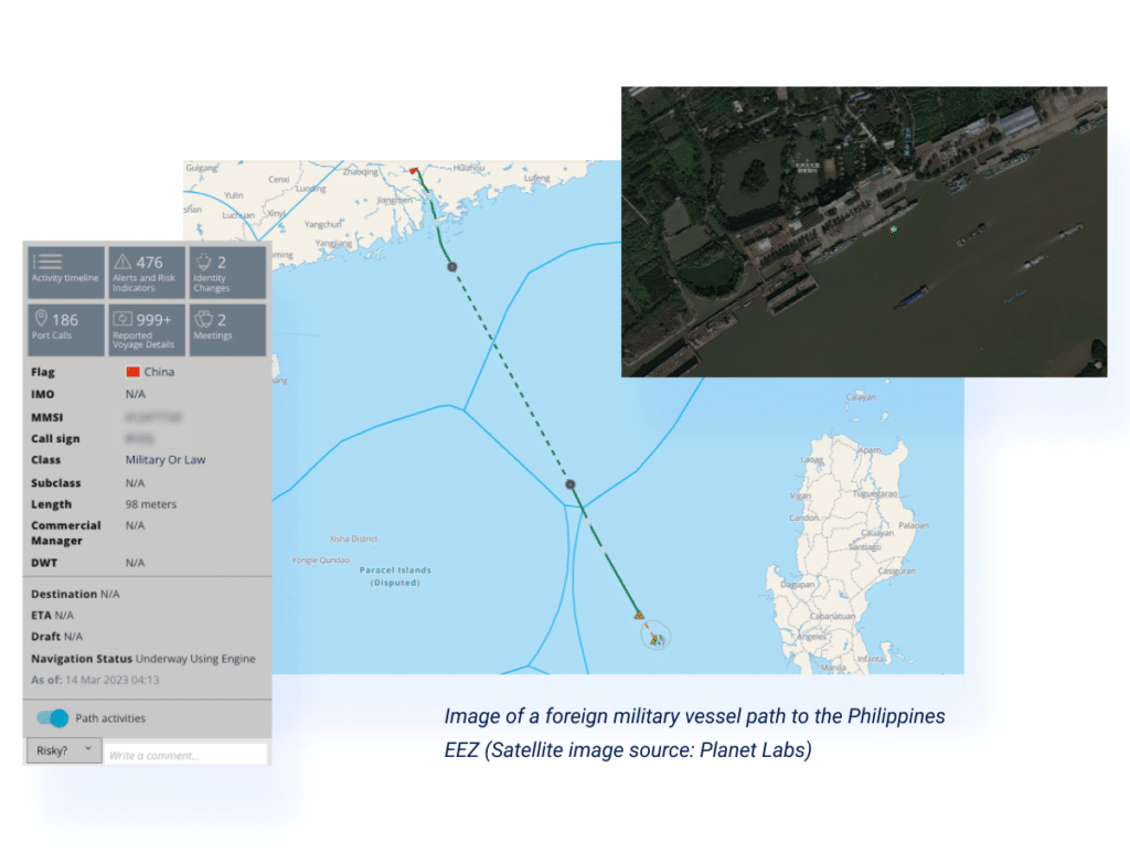
Their mission was clear: confirm foreign military activity within the Philippines’ Exclusive Economic Zone (EEZ).

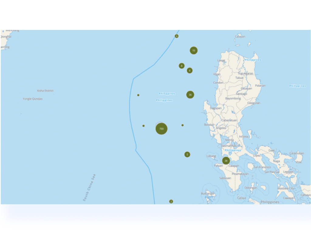
Leveraging Windward’s Maritime AI™ and sophisticated behavioral analysis, the unit rapidly pinpointed the highest-probability area for successful surveillance. They achieved this by conducting a targeted query for military vessels exhibiting slow-speed operations — typically indicative of maritime patrol missions—within the designated EEZ.

For Blog web page 5

With the search results and the identified polygon for the tasking, the unit was still missing the trigger for the tasking (timing, behavioral).
Within the defined polygon, the unit investigated the operations of non-commercial vessels to discover the following sequence and timeline:

  • Departure from China coast guard dock
  • 2 days later – the vessels arrive at the area of patrol in the Philippines EEZ
  • 1 day later – the replaced vessel departs from the area of patrol

By creating a custom polygon around the identified docks of interest, the unit customized alerts on triggers for tasking assets of importance, so as and not to miss a valuable opportunity.

For Blog web page 6 1

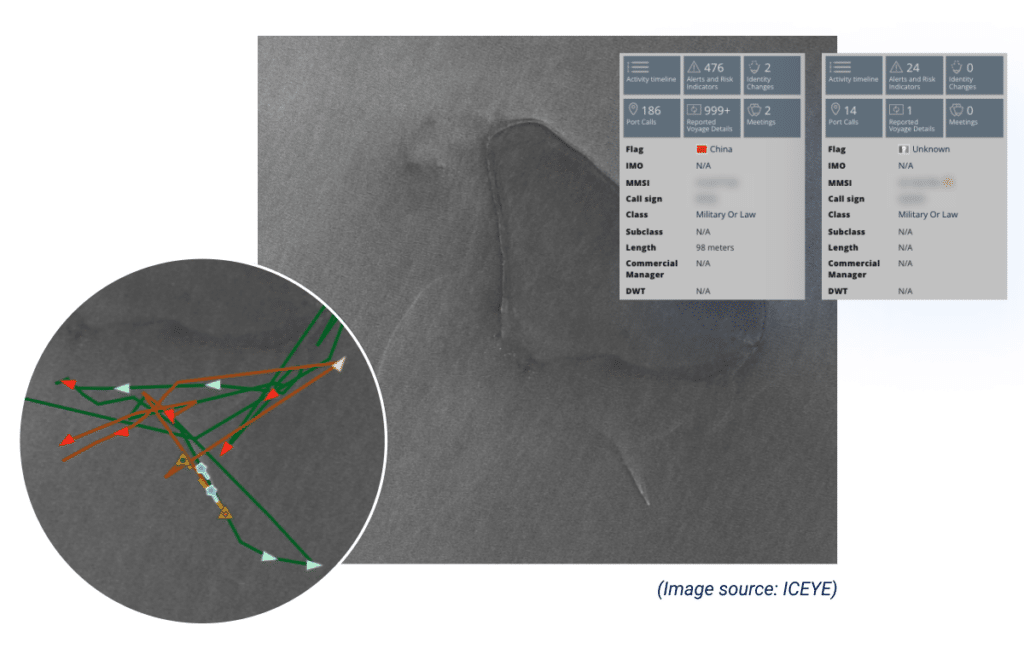
With the identified location, trigger, and timing in hand, the unit tasked SAR imagery and got the below images proving the sequence they discovered in the data. However, without vessel details and context, it’s difficult to make sense of the image or use it in their investigation.

For Blog web page 7

To leverage the SAR imagery further, the unit seamlessly integrated it into the Windward platform. Following this overlay with Windward AI’s fused identity layers, the actionable insights were highlighted to help drive the investigation deeper:

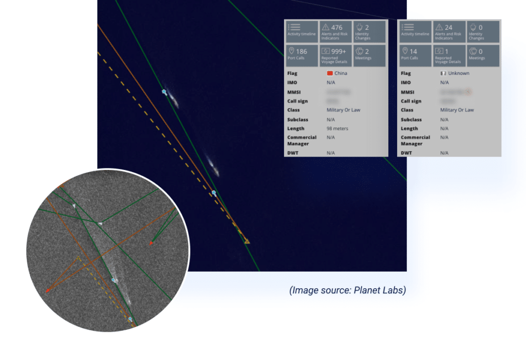
For Blog web page 8

Windward’s agnostic multi-source AI platform also provides an additional optical imagery sensor source (Planet Labs), which corroborated the vessels’ location, and added context for the investigated operation.

Looking to Increase Visibility & Optimize Your Decision Making?