


July 12, 2026
Iran Formally Closes the Strait of Hormuz as the U.S. Launches a Third Round of Strikes


Maritime Visibility Collapses as Tensions Escalate Around Hormuz

What’s inside?
At a Glance
- Maritime visibility across Hormuz and the Gulf of Oman deteriorated sharply following the launch of Project Freedom.
- Approximately 470 vessels were impacted by GPS jamming near Fujairah within 24 hours, while widespread AIS shutdowns further reduced maritime visibility.
- SAR imagery from May 5 detected 167 commercial-size vessels near Hormuz, including 146 operating dark and largely stationary.
- The attack on HMM NAMU was likely deliberate and coincided with strikes on UAE-linked energy infrastructure.
- Fujairah exports collapsed from typical levels of 3.5–4 million barrels per day to approximately 500,000 barrels following the May 4 attack.
- Kharg Island continues operating under sustained dark conditions, including covert VLCC loading activity and the identification of sanctioned tanker MT VIRGO.
- IRGC fast craft deployments, VHF transit warnings, vessel detention, and expanding AIS suppression are increasing operational pressure on commercial shipping.
- Alternative routing through the Sunda and Lombok Straits, AIS spoofing, and “safe transit” coordination claims indicate rapid adaptation by Iran-linked maritime networks.
Operational Overview
Maritime conditions around the Strait of Hormuz are entering a significantly more unstable phase as kinetic attacks, electronic interference, and coercive maritime control converge into a single operating environment.
Since the launch of Project Freedom, commercial shipping has faced simultaneous military, navigational, and compliance pressure. GPS jamming has intensified around Fujairah and Khor Fakkan, AIS visibility has deteriorated sharply, and satellite imagery increasingly shows large concentrations of stationary dark vessels across both sides of the Strait.
At the same time, commercial traffic is becoming more exposed to direct operational pressure. The likely deliberate targeting of HMM NAMU, the detention of MSC FRANCESCA following AIS suppression, IRGC transit warnings over VHF, and coordinated attacks on UAE-linked energy infrastructure all point to a maritime environment where visibility, routing, and vessel behavior are now directly tied to security risk.
The disruption is already affecting commercial flows. Fujairah exports have fallen sharply following the May 4 strikes, while Kharg Island continues covert loading operations under near-total concealment. Iranian-linked tankers are also adapting routing behavior, increasingly using longer and less visible approaches through Indonesia’s Sunda and Lombok Straits.
The result is a fragmented operating environment where commercial shipping must navigate physical attacks, degraded electronic visibility, mounting compliance exposure, and increasingly militarized transit conditions simultaneously.
The HMM NAMU Attack Was Likely Deliberate
The attack on HMM NAMU was almost certainly deliberate.
The IRGC issued direct VHF warnings to vessel masters at Mina Saqr and Ras Al Khaimah on May 3, naming the anchorage zone where HMM NAMU was positioned. The vessel remained in place for more than 32 hours after the warning, making it a stationary and trackable target.

The vessel’s South Korean nexus is also significant. South Korea is a formal U.S. treaty ally, and the attack on a South Korea-affiliated vessel sends a clear signal that allied-nation operators are not exempt from risk.
The timing further supports deliberate targeting. HMM NAMU was attacked on the same operational day as the ADNOC Barakah drone strike and Fujairah Oil Zone attack. These three target types — allied shipping, a UAE state asset, and UAE energy infrastructure — indicate coordinated targeting rather than opportunistic action.
The attack also falls inside Iran’s self-declared maritime control zone. On May 4, the IRGC published an expanded maritime control zone explicitly covering Umm Al Quwain. The attack and declaration on the same day indicate that Iran is enforcing its claimed jurisdiction kinetically.
Bulk Carrier Goes Dark Before Fire Near Mina Saqr
A bulk carrier anchored in the Ras Al Khaimah and Mina Saqr corridor caught fire on May 4, approximately 14 nautical miles west of Mina Saqr.
The leading candidate vessel is a Panama-flagged bulk carrier. Its last AIS transmission was recorded at 13:39 UTC on May 4, approximately 15–16 nautical miles from the reported incident site. The vessel then went dark roughly 2.5 hours before the fire was reported.

This AIS gap is the strongest single indicator. The loss of signal before the reported fire is consistent with a casualty event disabling onboard electrical or AIS systems before the incident reached UKMTO reporting channels.
The vessel had been anchored in the Ras Al Khaimah and Mina Saqr corridor since April 27, inside the IRGC VHF warning zone, and had filed Ras Al Khaimah as its destination. The vessel had no sanctions flags or elevated compliance profile, reinforcing that the incident appears linked to location and exposure rather than vessel-specific sanctions risk.
The Fujairah Strike Disrupts UAE Export Activity
On May 4 and 5, 2026, the attack on Fujairah, the UAE’s primary oil export terminal on the Gulf of Oman, triggered an immediate and measurable collapse in tanker activity.
Wet cargo departures from Fujairah dropped to 1.22 million barrels on May 4, the day of the attack, and then fell further to approximately 500,000 barrels on May 5. This compares to a 30-day average of approximately 3.5–4 million barrels per day. By May 6, UAE crude exports had fallen to approximately 1.35 million barrels per day, compared to a 10-year seasonal average of 3.25 million barrels per day.

The attack targeted the VTTI oil terminal within the Fujairah Oil Industry Zone (FOIZ). Satellite imagery confirmed that the fire remained active across both May 4 and May 5, indicating sustained infrastructure damage rather than a short-duration strike event.
The Fujairah strike occurred during the same operational window as the drone strike on the ADNOC-operated VLCC MV BARAKAH (IMO 9902615) while transiting Hormuz in ballast. Together, the incidents indicate coordinated pressure on the UAE’s energy export chain rather than isolated attacks.
A SAR image from May 5 at 02:14 UTC showed 10 vessels in Fujairah port, including four tankers at berth. A comparable image from May 3 showed 17 vessels in port, with most transmitting AIS.

By May 6, the anchorage pattern had deteriorated significantly. Across the Fujairah anchorage area, only approximately 10 of more than 100 vessels remained AIS-visible, consistent with intensified GPS jamming and deliberate AIS shutdowns by operators responding to the security environment.
Anchorage congestion also increased sharply, with vessel counts exceeding 100 while departures slowed, indicating disrupted loading and lifting cycles. SPM utilization shifted from partial occupancy on April 18 to full utilization on May 3, before dropping again after the strike, with one SPM vacated and no replacement VLCC approaching.
As of May 5 at 12:03 UTC, Windward observed a decreased loading and export pattern for tankers at Fujairah. The port appears severely affected by erratic AIS signals, with satellite imagery and AIS suggesting limited movement at key loading berths.

The operational impact is now extending beyond visibility loss. More than 100 vessels are operating in a congested and electronically degraded anchorage environment, increasing navigational uncertainty and operational risk during approach and mooring operations.
The disruption is also beginning to affect market behavior. Tanker operators have now observed both a major export terminal strike and a drone attack against a VLCC in the same operating window, conditions likely to increase war-risk insurance premiums and suppress near-term lifting activity.
Iranian state media has attributed the attacks to “unknown” actors, while the IRGC simultaneously continues broadcasting direct transit warnings over VHF. This disconnect between public messaging and operational behavior increases the risk of further uncontrolled escalation.
Visibility Across Hormuz Is Rapidly Deteriorating
GPS jamming has returned at very high levels around Hormuz, particularly near Fujairah and Khor Fakkan.
Windward observed a clear change over the past 48 hours in vessels broadcasting position data on both sides of the Strait. Shipowners appear to be switching off AIS for safety reasons, while GPS jamming is degrading positional reliability across key port and anchorage areas.

Approximately 470 vessels were impacted by GPS jamming off Fujairah in the past 24 hours. Three newly identified GPS jamming clusters were observed near Fujairah in May 5 imagery.

This creates a dual visibility problem: some vessels are deliberately switching off AIS, as permitted under SOLAS for security and safety reasons, while others may be affected by electronic interference. The result is a sharp increase in tracking opacity across both sides of the Strait.
IRGC Fast Craft Activity Increases Near Commercial Corridors
Imagery from May 6 at 07:30 UTC detected a formation of 39 IRGC fast craft moving westward through the eastern Strait of Hormuz corridor at speeds estimated between 18 and 25 knots.

The group likely departed from the Seerik area along the Iranian coastline and appeared to be heading toward the Omani Peninsula and the southern commercial corridor of the Strait.
The movement is operationally significant because it coincides with elevated GPS jamming, widespread AIS suppression, reduced commercial transit activity, and ongoing IRGC VHF transit warnings. The concentration and coordinated movement of fast craft in the eastern corridor increases operational pressure on commercial shipping during a period of already degraded maritime visibility.
Dark Vessel Activity Across the Strait of Hormuz
Dark activity in the Strait of Hormuz has surged to its highest levels since the launch of Operation Epic Fury. Windward data shows a sharp increase in vessels switching off AIS transponders as operators respond to the increasingly contested operating environment.

Dark activity peaked at 671 incidents on May 2, with the 7-day rolling average rising to approximately 470 incidents per day. Thousands of vessels across the Arabian Gulf and Gulf of Oman are now operating with degraded or absent positional visibility due to a combination of deliberate AIS suppression and intensified GPS jamming.

On May 5 at 02:14 UTC, 167 vessels were identified across the Strait of Hormuz area.

Of these, 146 were dark. The matched vessels were almost entirely Iran-domestic short-sea vessels, including cargo vessels, landing craft, service vessels, and one naval landing craft. The flag mix was dominated by Iran, with 19 Iranian-flagged vessels, one Hong Kong-flagged vessel, and one Comoros-flagged vessel.
The dark fleet was concentrated in three main clusters: the Bandar Abbas and Qeshm North anchorage shelf, the UAE south belt around Fujairah, Khor Fakkan, and the Ras Al Khaimah outer roads, and the western Strait approach near the Tunbs.
None of the 167 vessels showed clear wake evidence. No outbound or inbound transit count is asserted from this pass, as the full strip presents as a stationary anchorage signature consistent with queue-up posture across both shores.
A separate evening assessment through 17:17 UTC found no AIS-transmitting commercial transits through the Strait. One dark vessel, likely a VLCC between 300 and 330 meters, appeared to begin an outbound transit through the commercial lane before making a U-turn mid-transit inside Oman’s EEZ.

Stationary Dark Clusters Form Near North Hormuz Islands
On May 5 at 08:35 UTC, 15 commercial vessels were detected near the North Hormuz Islands.
All 15 were dark and stationary. The detections included one Suezmax, one large general cargo vessel, one Panamax tanker, four handysize tankers, two coaster cargo vessels, three small general cargo vessels, and three small tankers.
No clear wake evidence was observed. All 15 vessels appeared stationary, with no signs of any vessel crossing Hormuz in the coverage area.

Kharg Continues Loading Under Near-Total Concealement
On May 5 at 13:33 UTC, four vessels were detected at Kharg Island, all dark.

The vessels included two VLCCs, one Aframax, and one Panamax. A fresh VLCC arrival was observed at the western Sea Island Terminal, Iran’s primary crude export berth. Another VLCC remained at the eastern T-jetty, where it had been observed loading for more than 24 hours.
A Panamax-class vessel was also confirmed still at the southeast T-jetty, marking a five-day continuous hold from May 1 to May 5. An Aframax in the northeast outer anchorage was likely a two-day hold.
This indicates continued dark loading and controlled throughput at Kharg Island despite broader visibility degradation and enforcement pressure.
Sanctioned MT VIRGO Identified Loading at Kharg
Windward analysis identified the sanctioned Iranian dark fleet VLCC MT VIRGO (IMO 9236250) loading at Kharg Island’s eastern terminal.
MT VIRGO is an OFAC-designated VLCC sailing under a fraudulent Botswana flag. The vessel has been dark since April 23 and shows identity manipulation indicators, including an MMSI change on April 1 and a callsign change on April 23, the same day its current dark period began.
Its last reported voyage loaded 2.01 million barrels of Iranian Heavy crude at Kharg Island on October 9, 2025, and discharged via ship-to-ship transfer near Singapore and Riau in February 2026.
MT VIRGO’s current loading posture is consistent with another covert Kharg-to-Singapore and Malacca ship-to-ship shuttle. It should be treated as a potential blockade breaker.
MSC FRANCESCA Detention Highlights the AIS Dilemma
MSC FRANCESCA (IMO 9401116), a Panama-flagged ultra-large container vessel, was intercepted by Iranian forces after attempting to transit the Strait of Hormuz following the ceasefire announcement.

The vessel had gone dark on April 22 and was later identified in the Strait of Hormuz north-islands cluster. Iran reportedly justified the detention based on the vessel’s AIS shutdown, while Panama argued at the IMO that SOLAS permits AIS suppression under security threat conditions.
The vessel is not sanctioned and has no prior history of dark activity, making the case operationally significant for commercial shipping. It highlights the growing dilemma for operators in the Strait: vessels broadcasting AIS remain vulnerable to targeting, while vessels switching AIS off risk interception or detention.
High-resolution EO imagery showed the vessel carrying relatively few containers, supporting the assessment that most cargo had already been discharged at UAE and Saudi ports before interception.
Iran-Linked Tanker Uses Sunda Strait to Reduce Visibility
A potential blockade-busting LPG tanker used the Sunda Strait route between Java and Sumatra to enter Asia from the Indian Ocean.
The vessel likely spoofed its location to conceal loading activity off Iran after the April 13 blockade and transited Hormuz on April 17–18. The Vietnamese-flagged tanker is not sanctioned, but its routing is notable.
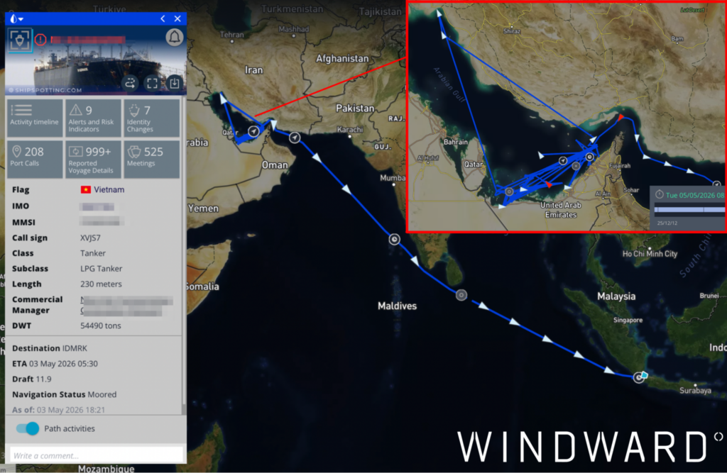
The choice of the Sunda Strait over the faster and more commercially viable Malacca route, while signaling China as the destination, suggests an effort to avoid detection. This route has been used intermittently by Iran-linked trade since the war began.
“Safe Transit” Claims Begin Emerging Around Hormuz
Early signs of commercial exploitation are emerging, with Iran-linked shipping companies advertising the ability to coordinate safe transits through Hormuz.
This is why the rapid restoration of freedom of navigation in the Strait of Hormuz is so important. I found this post on LinkedIn today advertising commercial services to facilitate Hormuz transits.
— Michelle Wiese Bockmann (@Michellewb_) May 5, 2026
Iranian companies advertising their coordination with the Iranian government… pic.twitter.com/3glOY2AY27
This signal is notable because public internet access in Iran has reportedly been unavailable since the start of the war. Whether the advertisements are genuine, scam activity, or enabled through alternate connectivity, they point to a broader risk.
If freedom of navigation remains degraded, transit coordination could become a monetized gray-market activity involving Iranian actors, intermediaries, or fraud networks.
Outlook
The Strait of Hormuz is shifting from a high-risk transit zone into an operationally degraded maritime environment shaped by simultaneous military pressure, electronic interference, and constrained commercial movement.
Commercial operators are increasingly trapped between competing risks. Broadcasting AIS may increase targeting exposure, while suppressing AIS raises the likelihood of detention, interception, or navigational uncertainty in already congested waters. At the same time, GPS jamming continues degrading positional reliability near key export and anchorage zones.
Dark vessel concentrations remain elevated across Hormuz, Fujairah, Bandar Abbas, Qeshm, and Kharg Island, while covert loading activity continues despite heightened enforcement pressure. Iranian-linked operators are also adapting rapidly through alternative routing, AIS manipulation, ship-to-ship transfers, and expanding use of less visible Asian transit corridors.The combination of kinetic attacks, electronic disruption, militarized signaling, and reduced export flows indicates that commercial shipping conditions around Hormuz are becoming structurally less stable rather than temporarily disrupted.
Explore more

The Ceasefire Collapses: 80+ Strikes, a Revoked Oil Waiver, and a 1.95-Million-Barrel U-Turn
At a Glance Operational Overview The Strait of Hormuz is once again operating under full conflict conditions. Overnight into July 8, U.S. Central Command struck more than 80 targets inside Iran in direct response to Iranian attacks on three commercial vessels transiting the Strait. Iran retaliated against U.S. military sites in Bahrain and Kuwait, President...
Read more

Hormuz’s NCAGS Corridor Under Attack: Two Laden Tankers Struck Overnight
At a Glance Operational Overview The Strait of Hormuz is functionally contested again. Overnight into July 7, the IRGC struck two laden tankers running dark on the NCAGS-approved outbound route, hitting a Qatari LNG carrier and a Saudi-owned ULCC in a single window. Six vessels rerouted from the southern corridor to the central corridor in...
Read more

Hormuz’s Stalled Recovery: Two Strikes and Suspended Evacuation
At a Glance Operational Overview The Strait of Hormuz is technically open, but it is not functioning as commercial infrastructure. Two kinetic incidents in 72 hours, an IMO evacuation corridor suspended without a resumption date, and total daily transits averaging approximately 13, roughly 90% below pre-war levels, collectively describe a corridor that is open in...
Read more

IRGC Orders Vessels to Turn Back: The Southern Corridor Reversal Stalls the Hormuz Recovery
At a Glance Operational Overview A week of widening commercial confidence in the Strait of Hormuz has run into the first significant test of the post-MoU operating environment. On June 25, the IRGC published a Telegram claim that vessels in the southern corridor had been ordered to turn back, with Windward identifying five vessels exhibiting...
Read more

Hormuz Re-Closure Meets Market Resistance as Traffic Returns
At a Glance Operational Overview The June 18-22 reporting period captures a rapid shift from cautious normalization to renewed uncertainty. Following the June 17 Memorandum of Understanding (MoU) and the formal lifting of the blockade on June 18, commercial shipping responded immediately. Transit volumes rose above 20 crossings per day, Chinese-affiliated and European-owned vessels resumed...
Read more