


April 14, 2026
April 14, 2026: Iran War Maritime Intelligence Daily


The Intelligence Revolution at Sea: Why Imagery Alone Isn’t Enough Anymore
What’s inside?
By Ami Daniel, Co-Founder & CEO, Windward
A funny thing happened on the way to making the oceans safer: shipping became headline news. What was once “inside baseball” – now changed: terms like GPS spoofing, dark activities, and deceptive shipping practices now dominate mainstream media investigations. Presidents tweet about shipping daily. Supply chain disruptions make front-page news.
This transformation reflects a harsh reality: as shipping moved into the spotlight, bad actors adapted. They didn’t retreat, they evolved. Reports show that GPS jamming has surged in both frequency and geographic spread since 2022, with some countries recording ten- to twenty-fold increases in disruptions. Today, jamming regularly affects maritime, with our platform detecting more than 3,400 GNSS manipulations across nearly 1,000 vessels in the past quarter alone.
Spoofing has rocketed to unprecedented levels. Dark activities and ships operating without proper identification or transparency have gone through the roof, with Russia’s shadow fleet alone expanding from fewer than 100 vessels in early 2022 to 300-600 by early 2025.
What’s truly staggering is the sheer expansion of the space infrastructure underpinning these capabilities.
In just four years, the number of operational satellites orbiting Earth has skyrocketed from fewer than 3,400 in 2020 to more than 11,500 by the end of 2024, thanks in large part to new “mega-constellations” and rapid proliferation of commercial platforms. That growth is not just in communication assets — Earth observation (EO), synthetic aperture radar (SAR), and radio frequency (RF) satellites now number in the thousands.
Leaders like Planet operate over 200 EO satellites, ICEYE runs the world’s largest SAR constellation with 50+ spacecraft, and UnseenLabs and Hawkeye360 deploy RF detection constellations with expanding coverage. The sector’s momentum shows no sign of slowing, with industry forecasts projecting over 18,000 additional imaging and sensing satellites to be launched in the coming decade, fundamentally changing how — and how often — we can see, analyze, and “listen” to what happens at sea and beyond.
Yet here’s the paradox: we’re data-rich but intelligence-poor.
Beyond the Snapshot Problem
The traditional approach to maritime surveillance has been reactive and fragmented. An incident occurs, someone tasks a satellite, an image gets delivered, and analysts manually scan for anomalies. This static snapshot model worked when threats were simpler and less sophisticated. It doesn’t work when adversaries are using zombie vessels, AIS handshakes, and identity laundering to evade detection.
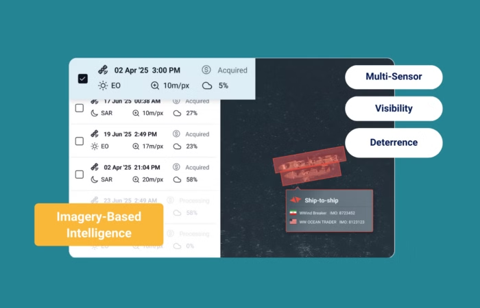
At Windward, we’ve spent over a decade tracking the world’s ships, and what we’ve learned is this: it’s not about imagery: it’s about Imagery-Based Intelligence. The difference is profound.
When you’re looking around the equator with dense cloud coverage, you need SAR imagery that penetrates weather conditions. When you need to see details in port facilities or examine ship-to-ship transfers, you need high-resolution electro-optical imagery. When you want to “listen” to vessels across vast water areas and detect those operating with manipulated or disabled AIS signals, you need RF data at scale.
But here’s the critical part: you need all of this integrated into a single platform, correlated with risk models, behavioral analytics, and automated workflows that turn data into decisions. You need to connect that as context to your generative AI Agents to streamline reporting and communication to stakeholders.
The Integration Imperative
The maritime intelligence market has reached an inflection point. Government agencies are spending over $490 million through NGA’s Luno contracts alone, while the UK’s Joint Maritime Security Centre has identified requirements for integrating 50+ additional data feeds. Japan is investing $876 million in its SHIELD coastal defense program, emphasizing multi-layered surveillance coordination.
These aren’t just procurement numbers — they represent a fundamental shift in how maritime security operates. The old model of single-source solutions is dead. The future belongs to platforms that can orchestrate multiple sensors, multiple data streams, and multiple intelligence sources into coherent, actionable insights.
This is why we’ve launched our new multi-sensor Imagery-Based Intelligence solution. It represents our response to customer feedback and market reality: the need for sensor-agnostic coverage that works across constellations, integrates RF, EO and SAR imagery for 24/7 visibility regardless of weather conditions, and incorporates built-in AI detection to accelerate time-to-insight.
The Deterrence Multiplication Effect
There’s a strategic dimension here that goes beyond operational efficiency. When we deployed AI to investigate the 2021 Israeli oil spill, we didn’t just identify the culprit vessel Emerald: we demonstrated that sophisticated evasion tactics like irregular shipping routes, falsified cargo manifests, and opaque ownership structures could be unraveled through intelligent data correlation.
The deterrence effect of this capability is multiplicative. Shipowners know that fines and reputational costs for maritime violations are extensive, with cleanup costs for major incidents reaching $2.4-9.4 billion. When advanced technology is patrolling the seas with persistent, multi-sensor coverage, bad actors lose their operational advantage.
But deterrence only works if the intelligence is actionable and the response is swift. That’s why our platform includes integrated case management, permanent image archives with no expiration, and transparent credit-based pricing that puts customers in control of when and where to deploy high-resolution assets.
The Path Forward
We’re at a unique moment in maritime history. Geopolitical tensions are turning shipping lanes into contested grounds. Shadow fleets are expanding. Sanctions enforcement is accelerating with newly sanctioned vessels rising 40% in Q1 2025 compared to Q2 2024. The maritime domain is becoming simultaneously more visible through satellite coverage and more opaque through deceptive practices.
This contradiction creates both challenge and opportunity. For those still operating with reactive, single-source approaches, the gap between threat sophistication and response capability will only widen. For those who embrace multi-sensor intelligence platforms that integrate data sources, automate detection, and accelerate decision-making, the operational advantage is decisive.
The overarching problem we’ve always tried to solve at Windward is bringing visibility to the oceans. Today, that mission requires more than just better cameras pointed at the sea. It requires intelligence systems that can think, correlate, and predict across multiple dimensions simultaneously.
As I’ve learned from over a decade in this space, never miss out on a good crisis. The current chaos in maritime security isn’t just a challenge to be managed, it’s an opportunity to fundamentally upgrade how we understand and secure the world’s waterways.
The question isn’t whether maritime intelligence will evolve to meet these new realities. The question is whether you’ll be ahead of the curve or behind it when the transformation accelerates.
*The choice, as they say, is yours. The technology is ready.*
Explore more

Maritime Defense Weekly: Energy Flows and Infrastructure Risk
Week in Focus Russian Diesel Cargo Signaling Arrival in Cuba A Hong Kong-flagged medium-range tanker is signaling arrival in Cuba on March 2 after multiple AIS destination revisions. The vessel initially broadcast Havana, then shifted to “Caribbean Sea,” and later to “Gibraltar for orders,” despite already transiting the strait. Windward’s assessment indicates the tanker likely...
Read more

Maritime Defense Weekly: Offshore Enforcement and Baltic Exposure
Week in Focus Sanctions Enforcement Moves Further Offshore The United States intercepted and boarded Aquila II (IMO 9281152) in the Indian Ocean, nearly 1,000 nautical miles from where it fled a Venezuelan quarantine zone in January. The 22-year-old Suezmax had falsely broadcast under the Panamanian flag and has a history of extended dark activity and...
Read more

Enforcement Shock Accelerates Dark Fleet Reflagging to Russia
At a Glance A Structural Shift in Russia’s Shadow Fleet At least 120 falsely flagged, sanctioned tankers are likely to reflag to Russia’s registry in the coming months, as Western interdictions of stateless shadow fleet vessels accelerates a structural shift in Russia’s oil export logistics. All ships fit the profile and trading pattern of tankers...
Read more

Maritime Defense Weekly: Enforcement Tightens Across Global Shipping
The Week in Focus Maritime Enforcement Is Shifting From Designation to Constraint Maritime enforcement is increasingly focused on restricting how vessels operate in practice, not just on whether they appear on a sanctions list. Rather than relying solely on designations, recent actions are targeting the services and access that make maritime trade possible, including insurance,...
Read more

Tracking RAIDER: How Long-Term Vessel Behavior Uncovered a Pacific Drug Operation
At a Glance How a Dormant Vessel Triggered a Major Seizure In January 2026, French naval forces interdicted the MV RAIDER, a 41-meter pontoon vessel, in French Polynesian waters, seizing nearly five tonnes of cocaine, with an estimated value of nearly $150 million. Although the vessel was released without charges, its risk profile illustrates how...
Read more